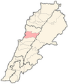
Adma wa Dafneh
This article needs additional citations for verification. (May 2020) |
Adma wa Dafneh
أدما والدفنة | |
|---|---|
Town | |
| Coordinates: 34°1′21″N 35°38′50″E / 34.02250°N 35.64722°E | |
| Country | |
| Governorate | Keserwan-Jbeil |
| District | Keserwan |
| Government | |
| • Mayor | Charbel Hanna Chahwan |
| Area | |
• Total | 2.733 km2 (1.055 sq mi) |
| Elevation | 215 m (705 ft) |
| Highest elevation | 330 m (1,080 ft) |
| Lowest elevation | 100 m (300 ft) |
| Population (2015[1]) | |
• Total | 2,497 |
| • Density | 913.5/km2 (2,366/sq mi) |
| Time zone | UTC+2 (EET) |
| • Summer (DST) | UTC+3 (EEST) |
| Dialing code | +961 |
| Website | Adma wa Dafneh |
Adma wa Dafneh or Adma (Arabic: أدْما والدّفنة or أدما) is a town in the Keserwan District of the Keserwan-Jbeil Governorate in Lebanon. The town consists of the villages of Adma and Dafneh. The town is located 27 kilometers north of Beirut on a cliff facing South.

Its elevation ranges between 100 and 330 meters above sea level and the town's total land area consists of 456 hectares. Adma wa Dafneh is markedly more vacant and vast than most Lebanese settlements, and is strongly connected to Jounieh and Tabarja to its south and north respectively. Adma wa Dafneh's inhabitants are predominantly Maronite Christians.[2]
Etymology
[edit]"Adam" (𐤀𐤃𐤌 in Phoenician) is derived from red, and there is an etymological connection between adam and admah, admah designating "red clay" or "red ground" in a non-theological context. The Village of Adma was named after its fertile and rich soil which was covered by vegetation before urbanisation.[3]
Topography and history
[edit]Topography
[edit]Adma wa Dafneh is largely made up of sparse structures situated between thick brush and forestation on the limestone hillsides and cliffs of Kasrouane.
History
[edit]In February 1990, following the Taif agreement ending the 15-year civil war, the town was the site of a battle between the Lebanese Army and the Lebanese Forces militia (LF). Two hundred commandos loyal to General Michel Aoun were trapped in their base in Adma wa Dafna by Samir Geagea’s LF fighters until a truce was arranged, 17 February, to allow their evacuation.[4] Traces of the fighting can still be seen. The town also features a ruined Lebanese Civil War-era structure with a hidden arms depository, now empty, that survived the war.
Residency and accommodations
[edit]Residency
[edit]Adma wa Dafneh today is mostly home to the upper mid-class and the high society, as well as foreign diplomats and international business men working in Lebanon. The town includes some of the most prestigious gated communities in Lebanon, such as BelHorizon Village and Admir. Mansions, large homes, as well as family buildings represent most of the dwellings in Adma.
Accommodations
[edit]The town has also managed to create its own ecosystem of accommodations which includes a Carrefour Market, convenience stores, gas stations, churches, a medical center, schools, restaurants, shops, hotels, etc.
References
[edit]- ^ "Adma and Dafneh, Mount Lebanon, Lebanon - Population". Retrieved 7 April 2023.
- ^ "Elections municipales et ikhtiariah au Mont-Liban" (PDF). Localiban. Localiban. 2010. p. 19. Archived from the original (PDF) on 24 July 2015. Retrieved 12 February 2016.
- ^ Campbell, Mike. "Meaning, origin and history of the name Adam". Behind the Name. Retrieved 7 April 2023.
- ^ Middle East International No 370, 2nd March 1990, Publishers Lord Mayhew, Dennis Walters MP; Jim Muir pp.6,7,8
External links
[edit]- Adma Oua Dafneh, localiban


