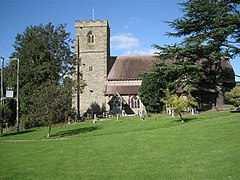
Mappleborough Green
| Mappleborough Green | |
|---|---|
 | |
Location within Warwickshire | |
| Population | 857 (2011) |
| OS grid reference | SP079659 |
| Civil parish |
|
| District | |
| Shire county | |
| Region | |
| Country | England |
| Sovereign state | United Kingdom |
| Post town | STUDLEY |
| Postcode district | B80 |
| Dialling code | 01527 |
| Police | Warwickshire |
| Fire | Warwickshire |
| Ambulance | West Midlands |
Mappleborough Green is a small village and civil parish in Warwickshire, in the non-metropolitan district of Stratford-on-Avon. The village has a population of 540[1] and the civil parish 857.[2]
Mappleborough Green lies on the extreme western edge of Warwickshire adjacent to Redditch and thus forming part of the county border with Worcestershire,[3] and adjoins the parishes of Studley, Tanworth-in-Arden, Beoley, Morton Bagot and Oldberrow.[4] The western edge of the parish is largely aligned with the A435 trunk road from Evesham to Birmingham.
History
[edit]Although likely settled since around 1200CE, Mappleborough Green was part of the Studley estate until 1824.[5] A church was built in the village in the Victorian era, financed by Sir William Jaffray Bart and remains in active use. A Wesleyan chapel in the village is no longer active.[5] The civil parish was formed on 1 April 2004 from Studley.[6]
Business
[edit]Mappleborough Green is primarily rural.[7] Local business includes farming and a concentration of garden centres.[1] These and the parish's country pubs serve the much larger population of Redditch.[8] The village also has a Chinese restaurant[1]
References
[edit]- ^ a b c "Mappleborough Green Parish Council". Mappleborough Green Parish Council. Retrieved 22 February 2014.
- ^ Neighbourhood Statistics (2011). "Key Statistics - Mappleborough Green - 2011 Census". Office for National Statistics. Retrieved 22 February 2014.
- ^ "Abstract Geometry 42570-280 - Mappleborough Green - Extent". Ordnance Survey. Retrieved 22 February 2014.
- ^ "Mappleborough Green". Ordnance Survey. 19 July 2013. Retrieved 22 February 2014.
- ^ a b "The Holy Ascension, Mappleborough Green". Arden Marches Group. Retrieved 22 February 2014.
- ^ "The Stratford-on-Avon (Parishes) Order 2004" (PDF). Local Government Boundary Commission for England. Retrieved 10 November 2022.
- ^ For example, the 2011 Census reports 4.2% of the population employed in Agriculture, Forestry and Fishing compared to 0.2% in nearby Church Hill. Mappleborough Green - Industry - Census 2011 Office for National Statistics
- ^ Both the Hollybush Inn and The Boot Inn advertise their convenience to Redditch, whereas The Dog identifies its location as Studley. All are within the parish of Mappleborough Green.
- "The Hollybush Inn, a country pub with a great atmosphere and fine food at Gorcott Hill near Redditch". The Hollybus Inn. Retrieved 22 February 2014.
- "The Boot Inn in Mappleborough Green - Find and contact us". The Boot Inn. Retrieved 22 February 2014.
- "The Dog, Studley: Find Us". Retrieved 22 February 2014.

