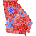
File:2022 United States Senate election in Georgia results map by county.svg
Appearance

Size of this PNG preview of this SVG file: 600 × 600 pixels. Other resolutions: 240 × 240 pixels | 480 × 480 pixels | 768 × 768 pixels | 1,024 × 1,024 pixels | 2,048 × 2,048 pixels | 810 × 810 pixels.
Original file (SVG file, nominally 810 × 810 pixels, file size: 90 KB)
File history
Click on a date/time to view the file as it appeared at that time.
| Date/Time | Thumbnail | Dimensions | User | Comment | |
|---|---|---|---|---|---|
| current | 05:14, 20 August 2024 |  | 810 × 810 (90 KB) | GatewayPolitics | fix |
| 05:13, 20 August 2024 |  | 810 × 810 (90 KB) | GatewayPolitics | Reverted to version as of 20:42, 9 October 2023 (UTC) | |
| 03:18, 20 August 2024 |  | 794 × 794 (689 KB) | GatewayPolitics | Quitman County was wrong | |
| 20:42, 9 October 2023 |  | 810 × 810 (90 KB) | Putitonamap98 | Reverted to version as of 20:18, 23 July 2023 (UTC) now it does i fix the one mistake on runoff map. these are the standard shapes and dimensions | |
| 13:24, 26 August 2023 |  | 744 × 744 (689 KB) | DixiePolitics | Reverted to version as of 00:02, 22 July 2023 (UTC) General map needs to correspond with the Runoff map | |
| 20:18, 23 July 2023 |  | 810 × 810 (90 KB) | CrookCoMaps61 | Fix | |
| 20:15, 23 July 2023 |  | 810 × 810 (89 KB) | CrookCoMaps61 | Reverted to version as of 22:03, 14 July 2023 (UTC) | |
| 00:02, 22 July 2023 |  | 744 × 744 (689 KB) | DixiePolitics | Reverted to version as of 13:14, 6 December 2022 (UTC) | |
| 22:03, 14 July 2023 |  | 810 × 810 (89 KB) | Putitonamap98 | shapes | |
| 13:14, 6 December 2022 |  | 744 × 744 (689 KB) | Elli | meaningful county names |
File usage
The following 2 pages use this file:
Global file usage
The following other wikis use this file:
- Usage on fi.wikipedia.org
- Usage on ja.wikipedia.org
- Usage on zh.wikipedia.org

