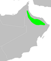
File:Al Hajar mountain woodlands map.png
Appearance

Size of this preview: 503 × 600 pixels. Other resolutions: 201 × 240 pixels | 402 × 480 pixels | 676 × 806 pixels.
Original file (676 × 806 pixels, file size: 18 KB, MIME type: image/png)
File history
Click on a date/time to view the file as it appeared at that time.
| Date/Time | Thumbnail | Dimensions | User | Comment | |
|---|---|---|---|---|---|
| current | 09:10, 27 February 2008 |  | 676 × 806 (18 KB) | Doreano~commonswiki | {{Information |Description=Al Hajar montane woodlands ecoregion map |Source=self-made |Date=2008/2/27 |Author= Altatoron |Permission= |other_versions= }} Category:Biomes Category:Biogeography Category:Maps of Oman |
File usage
The following 4 pages use this file:
Global file usage
The following other wikis use this file:
- Usage on ar.wikipedia.org
- Usage on ca.wikipedia.org
- Usage on es.wikipedia.org
- Usage on fa.wikipedia.org
- Usage on it.wikipedia.org
- Usage on ml.wikipedia.org
- Usage on nl.wikipedia.org
- Usage on nn.wikipedia.org
- Usage on sl.wikipedia.org
- Usage on uk.wikipedia.org
- Usage on www.wikidata.org
- Usage on zh.wikipedia.org
