
File:ArnoldExpeditionRouteMarked.jpg

Size of this preview: 242 × 600 pixels. Other resolutions: 97 × 240 pixels | 193 × 480 pixels | 310 × 768 pixels | 413 × 1,024 pixels | 2,240 × 5,552 pixels.
Original file (2,240 × 5,552 pixels, file size: 3.07 MB, MIME type: image/jpeg)
| This is a file from the Wikimedia Commons. Information from its description page there is shown below. Commons is a freely licensed media file repository. You can help. |
Summary
| Description |
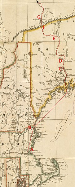
English: This is a detail from a 1795 map depicting the New England states. It is marked with the route of Benedict Arnold's expedition to Quebec City in September 1775.
Legend:
|
| Date | base map published by Henry Delahoy Symonds of New England in 1795, markings 2010 |
| Source | Source map from the Boston Public Library Map Collection |
| Author | John Russell (underlying map), User:Magicpiano (markings) |
Licensing
| I, the copyright holder of this work, release this work into the public domain. This applies worldwide. In some countries this may not be legally possible; if so: I grant anyone the right to use this work for any purpose, without any conditions, unless such conditions are required by law. |
File history
Click on a date/time to view the file as it appeared at that time.
| Date/Time | Thumbnail | Dimensions | User | Comment | |
|---|---|---|---|---|---|
| current | 17:08, 18 June 2010 | 2,240 × 5,552 (3.07 MB) | Magicpiano | Use a different base map. | |
| 19:21, 19 April 2009 |  | 2,618 × 4,631 (4.21 MB) | Magicpiano | {{Information |Description={{en|1=This is a detail from a 1780 map depicting the New England states. It is marked with the route of w:Benedict Arnold's expedition to w:Quebec City in September 1775. Legend: *A: [[w:Camb |
File usage
The following 4 pages use this file:
Global file usage
The following other wikis use this file:
- Usage on fr.wikipedia.org
- Usage on it.wikipedia.org
- Usage on ja.wikipedia.org
- Usage on ru.wikipedia.org
- Usage on www.wikidata.org
- Usage on zh.wikipedia.org