
File:Ashkelon1870s.jpg

Size of this preview: 800 × 501 pixels. Other resolutions: 320 × 200 pixels | 640 × 401 pixels | 1,024 × 642 pixels | 1,280 × 802 pixels | 1,877 × 1,176 pixels.
Original file (1,877 × 1,176 pixels, file size: 500 KB, MIME type: image/jpeg)
| This is a file from the Wikimedia Commons. Information from its description page there is shown below. Commons is a freely licensed media file repository. You can help. |
Summary
| Description |
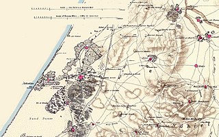
English: Portion of map produced by the Survey of Western Palestine, first published in 1880 by the Committee of the Palestine Exploration Fund. The editor, Walter Besant, died in 1901. This portion was made by the uploader out of portions of three sheets of the original map.
עברית: מפת הקרן לחקר ארץ ישראל לאזור אשקלון, משנת 1880 |
| Date | |
| Source | map produced by the Survey of Western Palestine, first published in 1880 by the Committee of the Palestine Exploration Fund |
| Author | Walter Besant, died in 1901 |
Licensing
|
This is a faithful photographic reproduction of a two-dimensional, public domain work of art. The work of art itself is in the public domain for the following reason:
The official position taken by the Wikimedia Foundation is that "faithful reproductions of two-dimensional public domain works of art are public domain".
This photographic reproduction is therefore also considered to be in the public domain in the United States. In other jurisdictions, re-use of this content may be restricted; see Reuse of PD-Art photographs for details. | ||||
File history
Click on a date/time to view the file as it appeared at that time.
| Date/Time | Thumbnail | Dimensions | User | Comment | |
|---|---|---|---|---|---|
| current | 09:43, 27 May 2007 | | 1,877 × 1,176 (500 KB) | Zero0000 | == Summary == Portion of map produced by the Survey of Western Palestine, first published in 1880 by the Committee of the Palestine Exploration Fund. The editor, Walter Besant, died in 1901. This portion was made by the uploader out of portions of three |
File usage
The following page uses this file:
Global file usage
The following other wikis use this file:
- Usage on de.wikipedia.org
- Usage on es.wikipedia.org
- Usage on he.wikipedia.org
- Usage on hr.wikipedia.org
- Usage on it.wikipedia.org
- Usage on lv.wikipedia.org
- Usage on pl.wikipedia.org
- Usage on zh.wikipedia.org