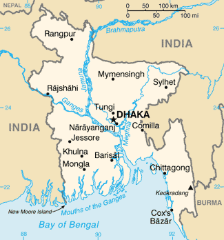
File:Bg-map.png
Appearance
Bg-map.png (325 × 348 pixels, file size: 16 KB, MIME type: image/png)
File history
Click on a date/time to view the file as it appeared at that time.
| Date/Time | Thumbnail | Dimensions | User | Comment | |
|---|---|---|---|---|---|
| current | 18:39, 12 March 2022 |  | 325 × 348 (16 KB) | Lojwe | Cropped 2 % horizontally, 2 % vertically using CropTool with precise mode. |
| 22:38, 26 February 2005 |  | 330 × 354 (16 KB) | Alfio | CIA map of Bangladesh |
File usage
The following 10 pages use this file:
- Bangladesh–Myanmar border
- Borders of Bangladesh
- Geology of Bangladesh
- List of twin towns and sister cities in Bangladesh
- Water supply and sanitation in Bangladesh
- Talk:Bangladesh/Archive 1
- Talk:Bangladesh/Archive 7
- User:Bettymnz4/Geology of Bangladesh
- User:Don'twasteTime/sandbox
- Portal:Bangladesh/FactSheet
Global file usage
The following other wikis use this file:
- Usage on ar.wikipedia.org
- Usage on as.wikipedia.org
- Usage on az.wikipedia.org
- Usage on ban.wikipedia.org
- Usage on ba.wikipedia.org
- Usage on bg.wikipedia.org
- Usage on bg.wiktionary.org
- Usage on bn.wikipedia.org
- Usage on bn.wiktionary.org
- Usage on ca.wikipedia.org
- Usage on ce.wikipedia.org
- Usage on cv.wikipedia.org
- Usage on da.wikipedia.org
- Usage on de.wikipedia.org
- Usage on de.wikinews.org
- Usage on de.wiktionary.org
- Usage on dsb.wikipedia.org
- Usage on el.wikipedia.org
- Usage on en.wikibooks.org
- Usage on en.wikinews.org
View more global usage of this file.


