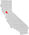
File:California county map (Yolo County highlighted).svg
Appearance

Size of this PNG preview of this SVG file: 508 × 600 pixels. Other resolutions: 203 × 240 pixels | 407 × 480 pixels | 651 × 768 pixels | 867 × 1,024 pixels | 1,735 × 2,048 pixels | 621 × 733 pixels.
Original file (SVG file, nominally 621 × 733 pixels, file size: 503 KB)
File history
Click on a date/time to view the file as it appeared at that time.
| Date/Time | Thumbnail | Dimensions | User | Comment | |
|---|---|---|---|---|---|
| current | 07:57, 26 December 2007 |  | 621 × 733 (503 KB) | Thadius856 | {{Information |Description= A county locator map of California, with Yolo County highlighted in red. |Source= Self-made. |Date= December 25, 2007 |Author= Thadius856 |Permission= Public Domain |other_versions= Based upon [[:Image:Blank |
File usage
The following 16 pages use this file:
- Davis station (California)
- Downtown Winters Historic District
- Downtown Woodland Historic District
- Dresbach–Hunt–Boyer House
- Gibson Mansion
- Hotel Woodland
- I.O.O.F. Building (Woodland, California)
- I Street Bridge
- Porter Building
- R. H. Beamer House
- Tower Bridge (Sacramento, California)
- Woodland Opera House
- Woodland Public Library
- Yolo Branch Library
- Yolo County Courthouse
- Template:NRHP in Yolo County, California
Global file usage
The following other wikis use this file:
- Usage on fi.wikipedia.org
- Usage on nl.wikipedia.org
- Usage on sv.wikipedia.org
