File:DJI 0019 6530b.jpg
Original file (3,992 × 2,242 pixels, file size: 7.41 MB, MIME type: image/jpeg)
![]() | This is a file from the Wikimedia Commons. Information from its description page there is shown below. Commons is a freely licensed media file repository. You can help. |
Summary
DescriptionDJI 0019 6530b.jpg |
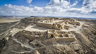
עברית: עבדת הייתה העיר המרכזית על ציר המסחר הנבטי שבין פטרה לנמל עזה המכונה דרך הבשמים. מרכז העיר (האקרופוליס) שוכן בהר הנגב, על שלוחת גבעה לצד ציר התנועה העתיק מצפון לדרום, וממזרח לכביש 40. הוא נישא לגובה של 655 מטר מעל פני הים, ומשקיף על סביבתו מרום של כ-80 מטר. כלל שטחה הבנוי של עבדת משתרע על כ-85 דונם, והיא ניצבת כיום במרכזו של גן לאומי בשטח של 2,100 דונם.
|
||
Date | |||
Source | Own work | ||
Author | ZeevStein |
Camera location | 30° 47′ 36.62″ N, 34° 46′ 20.64″ E ![]() | View this and other nearby images on: OpenStreetMap | ![]() |
---|
Licensing
- You are free:
- to share – to copy, distribute and transmit the work
- to remix – to adapt the work
- Under the following conditions:
- attribution – You must give appropriate credit, provide a link to the license, and indicate if changes were made. You may do so in any reasonable manner, but not in any way that suggests the licensor endorses you or your use.
- share alike – If you remix, transform, or build upon the material, you must distribute your contributions under the same or compatible license as the original.
![]() |
This image was one of 48 finalists in the national contest of Israel in "Wiki Loves Monuments 2018"
|
תמונה זאת הייתה אחת מ-48 התמונות שהגיעו לשלב הסופי בישראל של תחרות "ויקיפדיה אוהבת אתרי מורשת" לשנת 2018
|
![]() |
![]() |
This image was uploaded as part of Wiki Loves Monuments 2018.
Afrikaans ∙ Alemannisch ∙ العربية ∙ جازايرية ∙ azərbaycanca ∙ Bikol Central ∙ беларуская ∙ беларуская (тарашкевіца) ∙ български ∙ বাংলা ∙ brezhoneg ∙ bosanski ∙ català ∙ čeština ∙ Cymraeg ∙ dansk ∙ Deutsch ∙ Zazaki ∙ Ελληνικά ∙ English ∙ Esperanto ∙ español ∙ eesti ∙ euskara ∙ فارسی ∙ suomi ∙ français ∙ Frysk ∙ Gaeilge ∙ galego ∙ עברית ∙ हिन्दी ∙ hrvatski ∙ magyar ∙ հայերեն ∙ Bahasa Indonesia ∙ Ido ∙ italiano ∙ 日本語 ∙ ქართული ∙ 한국어 ∙ кыргызча ∙ Lëtzebuergesch ∙ latviešu ∙ Malagasy ∙ македонски ∙ മലയാളം ∙ Bahasa Melayu ∙ Malti ∙ norsk bokmål ∙ नेपाली ∙ Nederlands ∙ norsk nynorsk ∙ norsk ∙ polski ∙ português ∙ português do Brasil ∙ română ∙ русский ∙ sicilianu ∙ davvisámegiella ∙ slovenčina ∙ slovenščina ∙ shqip ∙ српски / srpski ∙ svenska ∙ ไทย ∙ Tagalog ∙ Türkçe ∙ українська ∙ اردو ∙ oʻzbekcha / ўзбекча ∙ Yorùbá ∙ 中文 ∙ 中文(中国大陆) ∙ 中文(简体) ∙ 中文(繁體) ∙ 中文(香港) ∙ 中文(臺灣) ∙ +/− |
![]() |
Captions
Items portrayed in this file
depicts
29 July 2017
30°47'36.618"N, 34°46'20.640"E
image/jpeg
0dd15f11ae132de0183fe2b647950578471e2eaa
7,768,086 byte
2,242 pixel
3,992 pixel
100
0.001 second
2.8
3.61 millimetre
File history
Click on a date/time to view the file as it appeared at that time.
Date/Time | Thumbnail | Dimensions | User | Comment | |
---|---|---|---|---|---|
current | 19:38, 28 September 2018 | ![]() | 3,992 × 2,242 (7.41 MB) | ZeevStein | User created page with UploadWizard |
File usage
The following page uses this file:
Global file usage
The following other wikis use this file:
Metadata
This file contains additional information, probably added from the digital camera or scanner used to create or digitize it.
If the file has been modified from its original state, some details may not fully reflect the modified file.
Camera manufacturer | DJI |
---|---|
Camera model | FC300X |
Author | Zeev Stein |
Copyright holder |
|
Exposure time | 1/1,000 sec (0.001) |
F-number | f/2.8 |
ISO speed rating | 100 |
Date and time of data generation | 08:29, 29 July 2017 |
Lens focal length | 3.61 mm |
Latitude | 30° 47′ 36.62″ N |
Longitude | 34° 46′ 20.64″ E |
Altitude | 622.283 meters above sea level |
Label | Red |
Image title |
|
Width | 3,992 px |
Height | 2,242 px |
Bits per component |
|
Pixel composition | RGB |
Orientation | Normal |
Number of components | 3 |
Horizontal resolution | 300 dpi |
Vertical resolution | 300 dpi |
Software used | Adobe Photoshop CS6 (Windows) |
File change date and time | 12:55, 21 October 2017 |
Exposure Program | 8176 |
Exif version | 2.3 |
Date and time of digitizing | 08:29, 29 July 2017 |
Shutter speed | 9.965784 |
APEX aperture | 2.970854 |
Exposure bias | 0 |
Maximum land aperture | 2 APEX (f/2) |
Subject distance | 0 meters |
Metering mode | Center weighted average |
Light source | Unknown |
Flash | Flash did not fire, No flash function |
Color space | Uncalibrated |
File source | Digital still camera |
Scene type | A directly photographed image |
Custom image processing | Normal process |
Exposure mode | Manual exposure |
White balance | Auto white balance |
Digital zoom ratio | 0 |
Focal length in 35 mm film | 20 mm |
Scene capture type | Standard |
Scene control | None |
Contrast | Normal |
Saturation | Normal |
Sharpness | Normal |
Subject distance range | Unknown |
GPS tag version | 0.0.3.2 |
Serial number of camera | 2014031100 |
Lens used | 20.7 mm |
Rating (out of 5) | 0 |
Date metadata was last modified | 14:55, 21 October 2017 |
Unique ID of original document | 47215B983C5782DCAD0884BA5654D1D2 |
IIM version | 4 |