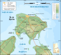
File:Djerba topographic map-en.svg
Appearance

Size of this PNG preview of this SVG file: 666 × 599 pixels. Other resolutions: 267 × 240 pixels | 533 × 480 pixels | 853 × 768 pixels | 1,138 × 1,024 pixels | 2,276 × 2,048 pixels | 1,100 × 990 pixels.
Original file (SVG file, nominally 1,100 × 990 pixels, file size: 564 KB)
File history
Click on a date/time to view the file as it appeared at that time.
| Date/Time | Thumbnail | Dimensions | User | Comment | |
|---|---|---|---|---|---|
| current | 18:37, 15 July 2011 |  | 1,100 × 990 (564 KB) | Morn | spelling correction |
| 14:42, 17 October 2010 |  | 1,100 × 990 (564 KB) | Morn | capitalization | |
| 14:40, 17 October 2010 |  | 1,100 × 990 (564 KB) | Morn | {{Information |Description={{en|Topographic map in French of Djerba Island, Tunisia.<br/>''Note:'' The shaded relief is a raster image embedded in the SVG file.}} {{fr|Carte topographique en français de l'île de Djerba, Tun |
File usage
The following page uses this file:
Global file usage
The following other wikis use this file:
- Usage on az.wikipedia.org
- Usage on bg.wikipedia.org
- Usage on cs.wikipedia.org
- Usage on fa.wikipedia.org
- Usage on he.wikipedia.org
- Usage on ko.wikipedia.org
- Usage on mk.wikipedia.org
- Usage on mr.wikipedia.org
- Usage on no.wikipedia.org
- Usage on uk.wikipedia.org
- Usage on ur.wikipedia.org


