
File:Hourglass Field over Miramar College B&W.jpg
Hourglass_Field_over_Miramar_College_B&W.jpg (469 × 424 pixels, file size: 72 KB, MIME type: image/jpeg)
| This is a file from the Wikimedia Commons. Information from its description page there is shown below. Commons is a freely licensed media file repository. You can help. |
Summary
| Description |
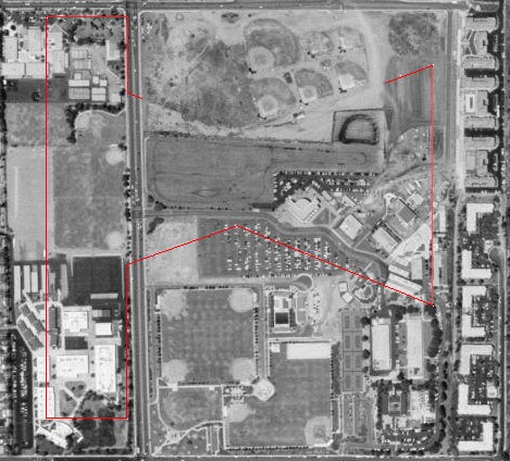
English: Aerial photo of Miramar College and Hourglass Field Community Park with the lost parts of the outline of Hourglass Field superimposed.
The outline and the size and positioning of the outline are based on photographs at freeman/CA/Airfields CA SanDiego N.htm#hourglass Abandoned & Little-Known Airfields: California: Northern San Diego Area. The outline was traced from freeman/CA/Hourglass CA 45.jpg this photograph, an overhead-view arial photo on the above page. The scale is based on a length of 2,400 feet for runway 18/36 (the north/south runway). Other evidence of the scale is the alignment of the western edge of runway 18/36 compared with the taxiway leading to Runway 28 at MCAS (NAS) Miramar as seen in freeman/CA/Hourglass Miramar CA 56.jpg this photograph, another aerial photo on the above page. This is compared to the position of the indent of the "hourglass" in the still-visible remains of the runway system. The apparently-still-visible eastern edge of the runway system in freeman/CA/Hourglass CA 00.jpg this photograph, the color aerial photo of Miramar College on the above page is further evidence of the scale and positioning. |
| Date | 1 June 2006 (original upload date) |
| Source |
Source: USGS photo from terraserver-usa.com. Modifications (outline of Hourglass Field) by Bob DuHamel.
|
| Author | Rsduhamel at en.wikipedia |
Licensing
| This file is licensed under the Creative Commons Attribution-Share Alike 3.0 Unported license. Subject to disclaimers. | ||
| Attribution: Rsduhamel at the English-language Wikipedia | ||
| ||
| This licensing tag was added to this file as part of the GFDL licensing update. |

|
Permission is granted to copy, distribute and/or modify this document under the terms of the GNU Free Documentation License, Version 1.2 or any later version published by the Free Software Foundation; with no Invariant Sections, no Front-Cover Texts, and no Back-Cover Texts. A copy of the license is included in the section entitled GNU Free Documentation License. Subject to disclaimers. |
Original upload log
Upload date | User | Bytes | Dimensions | Comment
- 2006-06-03 06:54 (UTC) | Rsduhamel | 73671 (bytes) | 469×424 |
- 2006-06-01 06:21 (UTC) | Rsduhamel | 80158 (bytes) | 535×429 | Aerial photo of Miramar College with the lost parts of the outline of Hourglass Field superimposed. Source: USGS photo from terraserver-usa.com. Modifications (outline of Hourglass Field) by Bob DuHamel. The original photo was public domain because it
File history
Click on a date/time to view the file as it appeared at that time.
| Date/Time | Thumbnail | Dimensions | User | Comment | |
|---|---|---|---|---|---|
| current | 10:58, 2 January 2012 | | 469 × 424 (72 KB) | SreeBot |
File usage
The following page uses this file:
Global file usage
The following other wikis use this file:
- Usage on www.wikidata.org