File:Jura-Simplon - Karte.jpg
Page contents not supported in other languages.
Tools
Actions
General
In other projects
Appearance

Size of this preview: 615 × 600 pixels. Other resolutions: 246 × 240 pixels | 492 × 480 pixels | 788 × 768 pixels | 1,050 × 1,024 pixels | 2,134 × 2,081 pixels.
Original file (2,134 × 2,081 pixels, file size: 3.87 MB, MIME type: image/jpeg)
| This is a file from the Wikimedia Commons. Information from its description page there is shown below. Commons is a freely licensed media file repository. You can help. |
Summary
| DescriptionJura-Simplon - Karte.jpg |
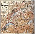
Deutsch: Die Jura–Simplon-Bahn (JS) war vor der Verstaatlichung eine der grossen Privatbahn-Gesellschaften der Schweiz. Sie entstand 1890/91 durch die Fusion der wichtigsten Westschweizer Bahnen Suisse-Occidentale–Simplon, Pont–Vallorbe und Jura–Bern–Luzern. |
| Date | |
| Source | Archiv Arthur Meyer |
| Author | Unknown authorUnknown author |
Licensing
| Public domainPublic domainfalsefalse |
The author of this image from Switzerland is unknown, and the image was published at least 70 years ago. It is therefore in the public domain in Switzerland by virtue of Art. 31 of the Swiss Copyright Act.
čeština | Deutsch | English | français | italiano | македонски | Nederlands | українська | +/− |
 |
| Public domainPublic domainfalsefalse |
This image is in the public domain in countries and areas where the copyright term for anonymous or pseudonymous works is 70 years from the year of first publication or less, for example in the European Union.
Please give also an explanation why the work is in the public domain in its source country and in the United States. If this work was published after 1928 and it was not in the public domain in its source country on the URAA date (January 1, 1996 for most countries), use {{Not-PD-US-URAA}} in addition to this template.
For files in the public domain in the EU, please use {{PD-anon-70-EU}} (see the documentation).
беларуская (тарашкевіца) | dansk | Deutsch | English | français | македонски | русский | 日本語 | suomi | +/− |
 |
| Public domainPublic domainfalsefalse |
This work is in the public domain in the United States because it was published (or registered with the U.S. Copyright Office) before January 1, 1929.
Public domain works must be out of copyright in both the United States and in the source country of the work in order to be hosted on the Commons. If the work is not a U.S. work, the file must have an additional copyright tag indicating the copyright status in the source country.
Note: This tag should not be used for sound recordings.PD-1923Public domain in the United States//commons.wikimedia.org/wiki/File:Jura-Simplon_-_Karte.jpg |
Captions
Add a one-line explanation of what this file represents
Items portrayed in this file
depicts
1894
4,062,006 byte
2,081 pixel
2,134 pixel
image/jpeg
d4c312f4e9efb155ac28412ceca47718926b41d0
File history
Click on a date/time to view the file as it appeared at that time.
| Date/Time | Thumbnail | Dimensions | User | Comment | |
|---|---|---|---|---|---|
| current | 14:26, 29 July 2014 |  | 2,134 × 2,081 (3.87 MB) | Plutowiki | User created page with UploadWizard |
File usage
The following page uses this file:
Global file usage
The following other wikis use this file:
- Usage on de.wikipedia.org
Metadata
This file contains additional information, probably added from the digital camera or scanner used to create or digitize it.
If the file has been modified from its original state, some details may not fully reflect the modified file.
| JPEG file comment | Jura-Simplon-Bahn (J-S): Karte von 1894, Plakat von 1897. Die Jura-Simplon-Bahn (J-S) war vor der Verstaatlichung eine der grossen Privatbahn-Gesellschaften der Schweiz. Sie entstand 1890-91 durch die Fusion der wichtigsten Westschweizer Bahnen (Suisse Occidentale-Simplon, Pont-Vallorbe, Jura-Bern-Luzern, ohne die vorher abgespaltene Jura-Neuchâtelois). Das Streckennetz von 937 km Länge führte von Basel, Genf und den Juragrenzübergängen Delle, La Chaux-de-Fonds, Les Verrières und Vallorbe bis nach Brig, Luzern und Meiringen (Anschluss an die ebenfalls der J-S gehörende meterspurige Brünigbahn) . Obwohl die J-S als eigene Gesellschaft nur 13 Jahre lang bestand, verhalf sie den jahrzehntelangen Bemühungen Berns und der Westschweiz um die Vollendung der Westalpentransversale zum Durchbruch. Die bis zur Fusion zersplitterten und in manchen Fällen chronisch defizitären Westschweizer Bahnen hatten die Kraft für den Simplontunnelbau nicht aufgebracht. Bern hatte in mehreren Anläufen die bernischen Bahnen subventioniert oder sogar staatlich geführt (1861-77 Bernische Staatsbahn). In der Genfersee-Region lösten sich Bahngesellschaften ab, die einen Simplontunnel bauen wollten (1853 Ligne internationale d'Italie par le Simplon, 1859 Ligne d'Italie, 1874 Simplon, 1881 Suisse Occidentale-Simplon). Dennoch hatten die Vorläuferbahnen der J-S bedeutende Leistungen – vor allem beim Bau der Juratransversalen - erbracht, so für die tunnelreiche Strecke von Delle durch den Jura, die Juraklusbahn entlang der korrigierten Birs bis Moutier/Münster-Granfelden, für die Bahnen auf das Hochplateau von La Chaux-de-Fonds und für die Transversale Vallorbe - Lausanne. Die J-S legte als unternehmerischer, junger und grösster Bahnkonzern der Schweiz dem Bundesrat schon 1891 ein definitives Simplontunnel-Projekt vor. 1895 gelang der Abschluss des Staatsvertrags mit Italien (Simplonverträge ), 1898 begannen die Bauarbeiten für den längsten Tunnel (19'803 m) der Welt. Die Kantonalbanken von Bern, Waadt, Neuenburg, Zürich und Solothurn betei |
|---|---|
| Orientation | Normal |
Retrieved from "https://en.wikipedia.org/wiki/File:Jura-Simplon_-_Karte.jpg"
