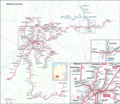
File:Karte Stadtbahn Karlsruhe.png
Appearance

Size of this preview: 691 × 599 pixels. Other resolutions: 277 × 240 pixels | 554 × 480 pixels | 886 × 768 pixels | 1,181 × 1,024 pixels | 2,362 × 2,048 pixels | 11,391 × 9,877 pixels.
Original file (11,391 × 9,877 pixels, file size: 38.36 MB, MIME type: image/png)
File history
Click on a date/time to view the file as it appeared at that time.
| Date/Time | Thumbnail | Dimensions | User | Comment | |
|---|---|---|---|---|---|
| current | 15:43, 28 June 2021 |  | 11,391 × 9,877 (38.36 MB) | Pechristener | Mühlburger Tor richtig gestellt |
| 21:22, 22 June 2021 |  | 11,391 × 9,877 (38.43 MB) | Pechristener | Korrekturen und Nachführungen | |
| 06:17, 1 October 2016 |  | 3,006 × 2,606 (6.21 MB) | Pechristener | korr Schrift, Verkehrsverbundlogos entfernt | |
| 17:57, 10 August 2016 |  | 3,006 × 2,606 (6.18 MB) | Pechristener | Zugpaar am WE nach Herrenberg hinzugefügt | |
| 16:55, 8 August 2016 |  | 3,006 × 2,606 (6.16 MB) | Pechristener | Schriftgrösse | |
| 15:39, 17 July 2016 |  | 3,006 × 2,606 (6.23 MB) | Pechristener | location map ergänzt | |
| 06:54, 17 July 2016 |  | 3,006 × 2,606 (6.39 MB) | Pechristener | Auschnitte von Karlsruhe Innenstadt und Heilbronn hinzu | |
| 04:53, 17 July 2016 |  | 3,000 × 2,601 (6.61 MB) | Pechristener | reduced size, old version crashes the browser | |
| 09:52, 9 July 2016 |  | 5,942 × 5,151 (13.45 MB) | Pechristener | == {{int:filedesc}} == {{Information |Description ={{en|1=Map of Stadtbahn Karlsruhe}}{{de|1=Karte der Stadtbahn Karlsruhe im Dezember 2015}} |Source =Map was created by using * [http:... |
File usage
The following page uses this file:
Global file usage
The following other wikis use this file:
- Usage on de.wikipedia.org
- Usage on fr.wikipedia.org
- Usage on hu.wikipedia.org
- Usage on ja.wikipedia.org
- Usage on nl.wikipedia.org
- Usage on uk.wikipedia.org
- Usage on www.wikidata.org


