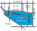
File:Little Portugal Toronto Map.png
Appearance
Little_Portugal_Toronto_Map.png (480 × 411 pixels, file size: 20 KB, MIME type: image/png)
File history
Click on a date/time to view the file as it appeared at that time.
| Date/Time | Thumbnail | Dimensions | User | Comment | |
|---|---|---|---|---|---|
| current | 19:23, 11 March 2010 |  | 480 × 411 (20 KB) | Alaney2k | Added Queen Street labels. |
| 19:12, 11 March 2010 |  | 480 × 411 (17 KB) | Alaney2k | Updated to show area east of Dufferin | |
| 18:40, 11 March 2010 |  | 480 × 411 (16 KB) | Alaney2k | {{Information |Description={{en|1=Map of Little Portugal neighbourhood in Toronto, Canada}} |Source={{own}} |Author=Alaney2k |Date=March 11, 2010 |Permission= |other_versions= }} Category:Toronto |
File usage
The following 2 pages use this file:
Global file usage
The following other wikis use this file:
- Usage on fa.wikipedia.org
- Usage on ms.wikipedia.org
- Usage on pt.wikipedia.org


