
File:Macro-arawakan-Languages.png

Size of this preview: 600 × 600 pixels. Other resolutions: 240 × 240 pixels | 480 × 480 pixels | 768 × 768 pixels | 1,024 × 1,024 pixels | 1,500 × 1,500 pixels.
Original file (1,500 × 1,500 pixels, file size: 110 KB, MIME type: image/png)
| This is a file from the Wikimedia Commons. Information from its description page there is shown below. Commons is a freely licensed media file repository. You can help. |
| Description |
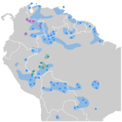
English: Proper Arawak Languages (Maipurean) (blue), Arawan Languages (green), Wahiboan languages (violet). Documented locations languages at present are signaled by spots, and approximate early probable areas are shadowed. Based on data of Alexandra Y. Aikhenvald "The Arawak Languages" in The Amazonian Languages, Dixon & Alexandra Y. Aikhenvald (eds.), Cambridge: Cambridge University Press, 1999. p. 65-106., p. 292-306 & p. |
||
| Date | |||
| Source | Own work | ||
| Author | Davius | ||
| Permission (Reusing this file) |
|
File history
Click on a date/time to view the file as it appeared at that time.
| Date/Time | Thumbnail | Dimensions | User | Comment | |
|---|---|---|---|---|---|
| current | 12:54, 15 November 2009 | | 1,500 × 1,500 (110 KB) | Davius | Redrawed the Tukano-Maku area in Colombia-Brasil border. |
| 12:51, 15 November 2009 |  | 1,500 × 1,500 (110 KB) | Davius | Redrawed the Tukano-Maku area in Colombia-Brasil border. | |
| 23:24, 14 November 2009 |  | 1,500 × 1,500 (108 KB) | Davius | {{Information |Description={{en|1=Norht Arawakan languages (light blue) and South-Western Arawak (dark blue) documented languages areas and approximate early probable areas. Based on data of Alexandra Y. Aikhenvald "The Arawak Languages" in ''The Amazonia |
File usage
The following page uses this file:
Global file usage
The following other wikis use this file:
- Usage on ca.wikipedia.org
- Usage on eo.wikipedia.org
- Usage on eo.wiktionary.org
- Usage on es.wikipedia.org
- Usage on gl.wikipedia.org
- Usage on hr.wikipedia.org
- Usage on it.wikipedia.org
- Usage on lt.wikipedia.org
- Usage on sh.wikipedia.org
- Usage on sr.wikipedia.org
- Usage on uk.wikipedia.org
- Usage on zh.wikipedia.org