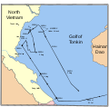
File:MaddoxTonkin1.svg
Appearance

Size of this PNG preview of this SVG file: 608 × 599 pixels. Other resolutions: 244 × 240 pixels | 487 × 480 pixels | 779 × 768 pixels | 1,039 × 1,024 pixels | 2,078 × 2,048 pixels | 685 × 675 pixels.
Original file (SVG file, nominally 685 × 675 pixels, file size: 73 KB)
File history
Click on a date/time to view the file as it appeared at that time.
| Date/Time | Thumbnail | Dimensions | User | Comment | |
|---|---|---|---|---|---|
| current | 02:46, 15 October 2007 |  | 685 × 675 (73 KB) | Interiot~commonswiki | fix tipo: "Golf"=>"Gulf" |
| 02:41, 15 October 2007 |  | 685 × 675 (73 KB) | Interiot~commonswiki | delineate countries on the left better | |
| 02:22, 15 October 2007 |  | 685 × 675 (57 KB) | Interiot~commonswiki | oops, add title back in | |
| 02:17, 15 October 2007 |  | 685 × 675 (56 KB) | Interiot~commonswiki | make it clear that this is a river, and not a country boundary that splits Vietnam in half | |
| 02:07, 15 October 2007 |  | 685 × 675 (56 KB) | Interiot~commonswiki | {{Information |Description=Chart showing the US Navy's interpretation of the events of the first part of the Gulf of Tonkin incident. |Source=http://www.history.navy.mil/photos/images/h96000/h96348.jpg |Date= |Author=Created by the U.S. Navy, and converte |
File usage
The following 2 pages use this file:
Global file usage
The following other wikis use this file:
- Usage on cs.wikipedia.org
- Usage on es.wikipedia.org
- Usage on fi.wikipedia.org
- Usage on hu.wikipedia.org
- Usage on it.wikipedia.org
- Usage on ja.wikipedia.org
- Usage on ko.wikipedia.org
- Usage on pl.wikipedia.org
- Usage on pt.wikipedia.org
- Usage on ro.wikipedia.org
- Usage on sk.wikipedia.org
- Usage on uk.wikipedia.org
- Usage on vi.wikipedia.org
- Usage on zh.wikipedia.org

