
File:Map of Venango County Pennsylvania School Districts.png
No higher resolution available.
Map_of_Venango_County_Pennsylvania_School_Districts.png (304 × 351 pixels, file size: 11 KB, MIME type: image/png)
| This is a file from the Wikimedia Commons. Information from its description page there is shown below. Commons is a freely licensed media file repository. You can help. |
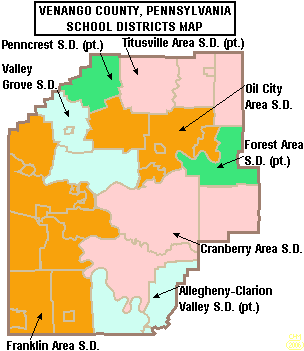
Summary
| Description | Map of Venango County, Pennsylvania, United States Public School Districts |
| Date | |
| Source | taken from US Census website [1] and modified by User:Ruhrfisch |
| Author | US Census, Ruhrfisch |
| Permission (Reusing this file) |
US Census / US Government work is public domain, my modifications licensed under the GNU Free Documentation License |
Licensing

|
Permission is granted to copy, distribute and/or modify this document under the terms of the GNU Free Documentation License, Version 1.2 or any later version published by the Free Software Foundation; with no Invariant Sections, no Front-Cover Texts, and no Back-Cover Texts. A copy of the license is included in the section entitled GNU Free Documentation License. |
| This file is licensed under the Creative Commons Attribution-Share Alike 3.0 Unported license. | ||
| ||
| This licensing tag was added to this file as part of the GFDL licensing update. |
File history
Click on a date/time to view the file as it appeared at that time.
| Date/Time | Thumbnail | Dimensions | User | Comment | |
|---|---|---|---|---|---|
| current | 00:35, 30 May 2006 | | 304 × 351 (11 KB) | Ruhrfisch | {{Information| |Description= Map of Venango County, Pennsylvania, United States Public School Districts |Source= taken from US Census website [http://factfinder.census.gov/] and modified by User:Ruhrfisch |Date= May 2006 |Author= US Census, Ruhrfisc |
File usage
The following 13 pages use this file:
- Allegheny-Clarion Valley Junior/Senior High School
- Allegheny-Clarion Valley School District
- Cranberry Area School District
- Forest Area School District
- Franklin Area School District
- Oil City Area School District
- Penncrest School District
- Titusville Area High School
- Titusville Area School District
- Valley Grove School District
- Venango Catholic High School
- Venango County, Pennsylvania
- Template:Venango County, Pennsylvania School Districts
Global file usage
The following other wikis use this file:
- Usage on ja.wikipedia.org
- Usage on www.wikidata.org