
File:Map of the Santa Cruz Islands (Solomon Islands).png
Size of this preview: 800 × 447 pixels. Other resolutions: 320 × 179 pixels | 640 × 358 pixels | 1,024 × 572 pixels | 1,280 × 715 pixels | 2,449 × 1,368 pixels.
Original file (2,449 × 1,368 pixels, file size: 175 KB, MIME type: image/png)
| This is a file from the Wikimedia Commons. Information from its description page there is shown below. Commons is a freely licensed media file repository. You can help. |
.png)
| Description |
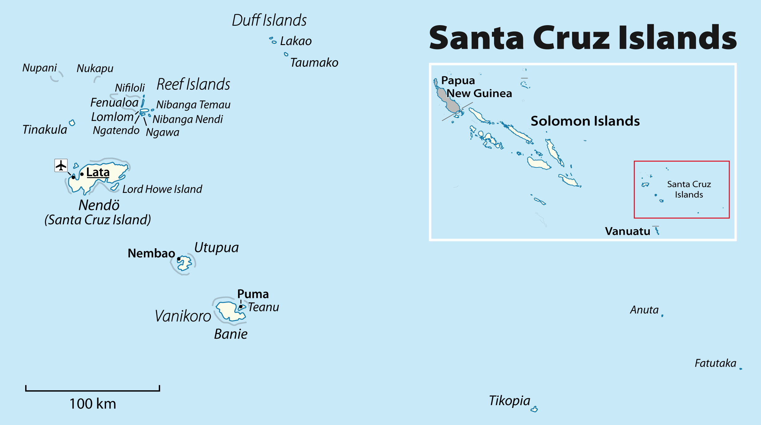
English: Map of the Santa Cruz Islands (Solomon Islands)
Deutsch: Karte der Santa-Cruz-Inseln (Salomonen) |
| Date | see file history |
| Source | Own work, using File:Solomon Islands location map.svg by NNW |
| Author | Maximilian Dörrbecker (Chumwa) |
| Permission (Reusing this file) |
This file is licensed under the Creative Commons Attribution-Share Alike 2.0 Generic license.
|
File history
Click on a date/time to view the file as it appeared at that time.
| Date/Time | Thumbnail | Dimensions | User | Comment | |
|---|---|---|---|---|---|
| current | 15:54, 8 March 2011 | | 2,449 × 1,368 (175 KB) | Chumwa | some corrections |
| 07:57, 6 March 2011 |  | 2,449 × 1,368 (181 KB) | Chumwa | Corrections and locator map | |
| 22:35, 5 March 2011 |  | 2,535 × 1,416 (125 KB) | Chumwa | changing font sizes | |
| 22:29, 5 March 2011 |  | 2,535 × 1,416 (129 KB) | Chumwa | {{Information |Description={{ en }} Map of the Santa Cruz Islands (Solomon Islands) {{ de }} Karte der Santa-Cruz-Inseln (Salomonen) |Author=Maximilian Dörrbecker (Chumwa) |Source={{own}}, using [[:File:Solomon Isl |
File usage
The following 8 pages use this file:
Global file usage
The following other wikis use this file:
- Usage on als.wikipedia.org
- Usage on ar.wikipedia.org
- Usage on arz.wikipedia.org
- Usage on ast.wikipedia.org
- Usage on az.wikipedia.org
- Usage on bg.wikipedia.org
- Usage on br.wikipedia.org
- Usage on ca.wikipedia.org
- Usage on ceb.wikipedia.org
- Usage on cs.wikipedia.org
- Usage on da.wikipedia.org
- Usage on de.wikipedia.org
- Usage on dsb.wikipedia.org
- Usage on en.wikivoyage.org
- Usage on eo.wikipedia.org
- Usage on es.wikipedia.org
- Usage on eu.wikipedia.org
- Usage on fa.wikipedia.org
- Usage on fi.wikipedia.org
- Usage on frr.wikipedia.org
- Usage on fr.wikipedia.org
- Usage on gl.wikipedia.org
- Usage on he.wikipedia.org
- Usage on hsb.wikipedia.org
- Usage on hu.wikipedia.org
View more global usage of this file.
.png)
.png)