Jump to content

File:Memorial J Kubitschek Brasilia 2009.jpg

Page contents not supported in other languages.
This is a file from the Wikimedia Commons
From Wikipedia, the free encyclopedia

Original file (4,311 × 2,744 pixels, file size: 4.79 MB, MIME type: image/jpeg)

Summary

Description
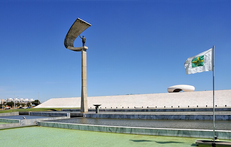
English: The JK Memorial in Brasília, dedicated to Juscelino Kubitschek (1902-1976), the founder of Brasília. The building was inaugurated in 1981. The architect is Oscar Niemeyer (1907-2012).
Čeština: Památník Juscelina Kubitscheka, věnováno Juscelinu Kubitschekovi de Oliveirovi (1902-1976), zakladateli Brasilie. Budova byla uvedena v provoz v roce 1981. Architektem byl Oscar Niemeyer (1907-2012).
Français : Le mémorial JK à Brasilia, dédié à la mémoire de Juscelino Kubitschek (1902-1976), le fondateur de Brasilia. Le mausolée, qui est l'oeuvre de l'architecte Oscar Niemeyer (1907-2012), fut inauguré en 1981.
Português: Memorial JK, dedicado a Juscelino Kubitschek (1902-1976), fundador de Brasília, capital do Brasil. O edifício, inaugurado em 1981, foi projetado pelo arquiteto Oscar Niemeyer (1907-2012).
Bosanski: Proslava dana Brasílije. Spomenik JK, posvećen Juscelinu Kubitscheku (1902-1976), osnivaču Brasílije, glavnog grada Brazila.
Deutsch: Denkmal zu Ehren Juscelino Kubitscheks (1902-1976), dem Gründer der brasilianischen Hauptstadt Brasília.
Español: El Memorial JK, dedicado a Juscelino Kubitschek (1902-1976), el fundador de Brasilia. El edificio fue diseñado por Oscar Niemeyer (1907-2012) e inaugurado en 1981.
Magyar: Juscelino Kubitscheknek, Brazíliaváros alapítójának szentelt JK-emlékmű Brazíliaváros évfordulóján
Italiano: Il memoriale dedicato a Juscelino Kubitschek de Oliveira a Brasilia, inaugurato nel 1981 e progettato da Oscar Niemeyer.
한국어: 브라질 건국일, 수도 브라질리아의 설립자 주셀리누 쿠비체크 (1902-1976)에 헌정된 JK 기념탑에서. 1981년에 개관한 이 건물은 오스카르 니에메예르 (1907-2012)가 건축하였다.
Nederlands: Een aan de voormalige Braziliaanse president Juscelino Kubitschek gewijd gedenkteken in de Braziliaanse hoofdstad Brasilia.
Date
Source Own work
Author Cayambe
Other versions
Camera location15° 47′ 03.2″ S, 47° 54′ 45.6″ W  Heading=202.5° Kartographer map based on OpenStreetMap.View this and other nearby images on: OpenStreetMapinfo

Featured picture

Wikimedia Commons

This is a featured picture on Wikimedia Commons (Featured pictures) and is considered one of the finest images. See its nomination here.

If you have an image of similar quality that can be published under a suitable copyright license, be sure to upload it, tag it, and nominate it.

This image has been assessed using the Quality image guidelines and is considered a Quality image.

العربية  جازايرية  беларуская  беларуская (тарашкевіца)  български  বাংলা  català  čeština  Cymraeg  Deutsch  Schweizer Hochdeutsch  Zazaki  Ελληνικά  English  Esperanto  español  eesti  euskara  فارسی  suomi  français  galego  עברית  हिन्दी  hrvatski  magyar  հայերեն  Bahasa Indonesia  italiano  日本語  Jawa  ქართული  кыргызча  한국어  kurdî  Latina  Lëtzebuergesch  lietuvių  македонски  മലയാളം  मराठी  Bahasa Melayu  Nederlands  Norfuk / Pitkern  polski  português  português do Brasil  qaraqalpaqsha  rumantsch  română  русский  sicilianu  slovenčina  slovenščina  shqip  српски / srpski  svenska  தமிழ்  తెలుగు  ไทย  Tagalog  toki pona  Türkçe  українська  Oʻzbekcha  vèneto  Tiếng Việt  中文  中文(简体)  中文(繁體)  +/−

Licensing

I, the copyright holder of this work, hereby publish it under the following license:
w:en:Creative Commons
attribution share alike
This file is licensed under the Creative Commons Attribution-Share Alike 3.0 Unported license.
You are free:
  • to share – to copy, distribute and transmit the work
  • to remix – to adapt the work
Under the following conditions:
  • attribution – You must give appropriate credit, provide a link to the license, and indicate if changes were made. You may do so in any reasonable manner, but not in any way that suggests the licensor endorses you or your use.
  • share alike – If you remix, transform, or build upon the material, you must distribute your contributions under the same or compatible license as the original.

Captions

Add a one-line explanation of what this file represents

Items portrayed in this file

depicts

28 October 2009

15°47'3.199"S, 47°54'45.601"W

heading: 202.5 degree

0.002 second

18 millimetre

File history

Click on a date/time to view the file as it appeared at that time.

Date/TimeThumbnailDimensionsUserComment
current09:28, 8 October 2012Thumbnail for version as of 09:28, 8 October 20124,311 × 2,744 (4.79 MB)CayambeUser created page with UploadWizard

The following page uses this file:

Global file usage

The following other wikis use this file:

Metadata