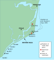
File:Orford Ness Map (UK).svg
Appearance

Size of this PNG preview of this SVG file: 492 × 549 pixels. Other resolutions: 215 × 240 pixels | 430 × 480 pixels | 688 × 768 pixels | 918 × 1,024 pixels | 1,835 × 2,048 pixels.
Original file (SVG file, nominally 492 × 549 pixels, file size: 26 KB)
File history
Click on a date/time to view the file as it appeared at that time.
| Date/Time | Thumbnail | Dimensions | User | Comment | |
|---|---|---|---|---|---|
| current | 20:16, 18 June 2011 |  | 492 × 549 (26 KB) | Hohum | and again |
| 20:12, 18 June 2011 |  | 492 × 549 (35 KB) | Hohum | trying to fix text formatting. | |
| 13:28, 21 February 2007 |  | 492 × 549 (35 KB) | NCC1291 | {{Information |Description=Map showing Orford Ness, historical extent, and sites of interest. Drawn by en:User:Jakew in Inkscape based on maps by [http://www.english-nature.org.uk/livingwiththesea/project_details/good_practice_guide/shingleCRR/shingl |
File usage
The following page uses this file:
Global file usage
The following other wikis use this file:
- Usage on cy.wikipedia.org
- Usage on de.wikipedia.org
- Usage on en.wikivoyage.org

