Jump to content

File:Pizzigani brothers 1367 map (Atlantic detail).jpg

Page contents not supported in other languages.
This is a file from the Wikimedia Commons
From Wikipedia, the free encyclopedia

Pizzigani_brothers_1367_map_(Atlantic_detail).jpg (515 × 497 pixels, file size: 23 KB, MIME type: image/jpeg)

Summary

Description
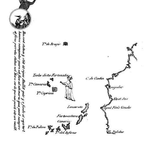
English: Detail of the Atlantic islands off the African coast in the 1367 portolan chart of the Pizzigani brothers (Domenico and Francesco Pizzigano) of Venice, as reproduced in the 1849 sketch of Edmé François Jomard (1777-1862). This detail depicts the Canary islands and the fictional cluster of St. Brendan.
Date
Source Magasin pittoresque, 1849
Author Domenico and Francesco Pizzigani

Licensing

Public domain

This work is in the public domain in its country of origin and other countries and areas where the copyright term is the author's life plus 100 years or fewer.


You must also include a United States public domain tag to indicate why this work is in the public domain in the United States.
This file has been identified as being free of known restrictions under copyright law, including all related and neighboring rights.

Captions

Add a one-line explanation of what this file represents

Items portrayed in this file

depicts

23,482 byte

497 pixel

515 pixel

image/jpeg

bf9e8ff1fbe3b8aa0ae97273d402b5be0bc8dc17

File history

Click on a date/time to view the file as it appeared at that time.

Date/TimeThumbnailDimensionsUserComment
current15:50, 15 June 2011Thumbnail for version as of 15:50, 15 June 2011515 × 497 (23 KB)Walrasiad{{Information |Description ={{en|1=Detail of the Atlantic islands off the African coast in the 1367 portolan chart of the Pizzigani brothers (Domenico and Francesco Pizzigano) of Venice, as reproduced in the 1849 sketch of Edmé François Jomard (1777-

The following page uses this file:

Global file usage

Metadata