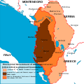
File:Principality of Albania.svg
Appearance

Size of this PNG preview of this SVG file: 600 × 600 pixels. Other resolutions: 240 × 240 pixels | 480 × 480 pixels | 768 × 768 pixels | 1,024 × 1,024 pixels | 2,048 × 2,048 pixels | 1,700 × 1,700 pixels.
Original file (SVG file, nominally 1,700 × 1,700 pixels, file size: 246 KB)
File history
Click on a date/time to view the file as it appeared at that time.
| Date/Time | Thumbnail | Dimensions | User | Comment | |
|---|---|---|---|---|---|
| current | 00:57, 20 November 2021 |  | 1,700 × 1,700 (246 KB) | Villarreal9 | File uploaded using svgtranslate tool (https://svgtranslate.toolforge.org/). Added translation for ru. |
| 17:11, 25 March 2011 |  | 1,700 × 1,700 (234 KB) | AnonMoos | Balkan land bgound | |
| 14:38, 25 March 2011 |  | 1,700 × 1,700 (235 KB) | Alexikoua | background fille | |
| 21:29, 24 March 2011 |  | 1,700 × 1,700 (231 KB) | Alexikoua | small legend adjustment | |
| 21:22, 24 March 2011 |  | 1,700 × 1,700 (231 KB) | Alexikoua | legent fixed | |
| 21:17, 24 March 2011 |  | 1,700 × 1,700 (231 KB) | Alexikoua | additional cities and legend | |
| 16:03, 21 March 2011 |  | 1,700 × 1,700 (214 KB) | Alexikoua | minor improvements | |
| 10:05, 21 March 2011 |  | 1,700 × 1,700 (309 KB) | Alexikoua | fixed scale | |
| 09:49, 21 March 2011 |  | 1,700 × 1,700 (309 KB) | Alexikoua | {{Information |Description ={{en|1=Proposed boundaries of the Principality of Albania: 1. By Russia, France in support of the Balkan League, 2. Fixed by Ambassadors Conference and Boudary Commission 1912-1914, 3. By the Prvisional Government of Albania |
File usage
The following 4 pages use this file:
Global file usage
The following other wikis use this file:
- Usage on bg.wikipedia.org
- Usage on de.wikipedia.org
- Usage on el.wikipedia.org
- Usage on fr.wikipedia.org
- Usage on hu.wikipedia.org
- Usage on it.wikipedia.org
- Usage on ja.wikipedia.org
- Usage on ka.wikipedia.org
- Usage on ko.wikipedia.org
- Usage on lt.wikipedia.org
- Usage on lv.wikipedia.org
- Usage on ml.wikipedia.org
- Usage on nl.wikipedia.org
- Usage on pt.wikipedia.org
- Usage on ro.wikipedia.org
- Usage on ru.wikipedia.org
- Usage on sq.wikipedia.org
- Usage on uk.wikipedia.org
- Usage on uz.wikipedia.org


