
File:Sf-map.png
No higher resolution available.
Sf-map.png (327 × 350 pixels, file size: 10 KB, MIME type: image/png)
| This is a file from the Wikimedia Commons. Information from its description page there is shown below. Commons is a freely licensed media file repository. You can help. |

|
File:Map of South Africa.svg is a vector version of this file. It should be used in place of this PNG file.
File:Sf-map.png → File:Map of South Africa.svg
For more information, see Help:SVG. |
 |
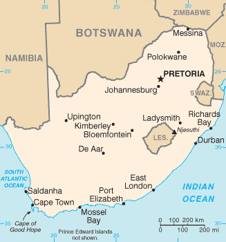
English: CIA map of South Africa
This image is in the public domain because it contains materials that originally came from the United States Central Intelligence Agency's World Factbook.
|
 |
derivative works
Derivative works of this file: Sf-map-sv.png
File history
Click on a date/time to view the file as it appeared at that time.
| Date/Time | Thumbnail | Dimensions | User | Comment | |
|---|---|---|---|---|---|
| current | 22:50, 5 August 2010 | | 327 × 350 (10 KB) | Ras67 | cropped |
| 21:02, 30 September 2006 |  | 329 × 353 (11 KB) | Samulili | Reverted to earlier revision | |
| 14:50, 29 September 2006 |  | 330 × 355 (15 KB) | Loveless | This image was copied from wikipedia:fr. The original description was: Carte de l'Afrique du Sud Tiré du CIA world factbook : http://www.cia.gov/cia/publications/factbook/geos/sf.html {{DomainePublic}} {| border="1" ! date/time || username || resoluti | |
| 23:11, 4 March 2005 |  | 329 × 353 (11 KB) | Alfio | CIA map of South Africa |
File usage
The following 3 pages use this file:
Global file usage
The following other wikis use this file:
- Usage on af.wikipedia.org
- Usage on ar.wikipedia.org
- Usage on ast.wikipedia.org
- Usage on azb.wikipedia.org
- Usage on bn.wikipedia.org
- Usage on bs.wikipedia.org
- Usage on ca.wikipedia.org
- Usage on ckb.wikipedia.org
- Usage on cs.wikipedia.org
- Usage on da.wikipedia.org
- Usage on diq.wikipedia.org
- Usage on en.wiktionary.org
- Usage on eo.wikipedia.org
- Usage on es.wikipedia.org
- Usage on fa.wikipedia.org
- Usage on fi.wikipedia.org
- Usage on fr.wikipedia.org
- Usage on gl.wikipedia.org
- Usage on he.wikipedia.org
- Usage on hif.wikipedia.org
- Usage on hi.wikipedia.org
- Usage on hr.wikipedia.org
- Usage on id.wikipedia.org
- Usage on io.wikipedia.org
- Usage on it.wikipedia.org
- Usage on ja.wikipedia.org
View more global usage of this file.