Jump to content

File:Sjogren glacier, Antartica.jpg

Page contents not supported in other languages.
This is a file from the Wikimedia Commons
From Wikipedia, the free encyclopedia

Original file (7,946 × 7,713 pixels, file size: 13.87 MB, MIME type: image/jpeg)

Summary

Description
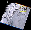
Português: Geleira Sjogren (área em destaque) que até 1995 desaguava no Canal Príncipe Gustavo, no S da Península Trinity, retrocedeu 20 km e formou essa enseada. Água do mar líquida em cor preta, congelada em cinza. Pontos e polígonos brancos no mar são icebergs, formados com desabamento de grandes pedaços de geleira. No mar em cinza azulado, onde termina a geleira, pedaços de gelo sem bolhas de ar, formado no fundo, transparentes e com isso azuis. Em branco neve e em marrom escuro e preto rochas expostas / Sjogren glacier (highlighted area), wich up to 1995 ended at Prince Gustav Channel, Southern Trinity Peninsula, calved 12+ miles and formed this inlet. Liquid sea water in black, sea ice in gray. White points and polygons at sea are icebergs, formed by glacier calving. At sea, in blueish grey where glacier ends, glacier bottom ice pieces, transparent because without air bubbles, and then blue. Snow in white and rock outcrops in black.
  1. sjogrenglacier #geleira #trinitypeninsula #gustavchannel #icebergs #geleirademaré #tidewaterglacier #blueice #seaice #glacierice #gelo #antartica #antarctic #antártica #antartida #sensoriamentoremoto #remotesensing #cbers4 #cbers #inpe #geotecnologias

Imagem / Image CBERS4 MUX Geleira Sjogren / Sjogren glacier, Antartica Coordenadas do centro da imagem / Image center: 64°13'15.0"S 59°04'17.6"W Data / Date: 20-01-2020 / 2020-20-01 RGB 765 (cor verdadeira / true color) Cena / Scene: 150 / 173 Autor / Author: Oton Barros (DSR/OBT/INPE)

Imagem em HD / HD Image

Visite-nos em www.dsr.inpe.br
Date
Source https://www.flickr.com/photos/153282474@N02/49497323058/
Author Coordenação-Geral de Observação da Terra/INPE

Licensing

w:en:Creative Commons
attribution share alike
This file is licensed under the Creative Commons Attribution-Share Alike 2.0 Generic license.
You are free:
  • to share – to copy, distribute and transmit the work
  • to remix – to adapt the work
Under the following conditions:
  • attribution – You must give appropriate credit, provide a link to the license, and indicate if changes were made. You may do so in any reasonable manner, but not in any way that suggests the licensor endorses you or your use.
  • share alike – If you remix, transform, or build upon the material, you must distribute your contributions under the same or compatible license as the original.
This image was originally posted to Flickr by Coordenação-Geral de Observação da Terra/INPE at https://flickr.com/photos/153282474@N02/49497323058. It was reviewed on 9 April 2020 by FlickreviewR 2 and was confirmed to be licensed under the terms of the cc-by-sa-2.0.

9 April 2020

Captions

Add a one-line explanation of what this file represents

Items portrayed in this file

depicts

6 February 2020

image/jpeg

File history

Click on a date/time to view the file as it appeared at that time.

Date/TimeThumbnailDimensionsUserComment
current10:12, 9 April 2020Thumbnail for version as of 10:12, 9 April 20207,946 × 7,713 (13.87 MB)Jo-Jo EumerusUploaded a work by Coordenação-Geral de Observação da Terra/INPE from https://www.flickr.com/photos/153282474@N02/49497323058/ with UploadWizard

The following page uses this file:

Global file usage

The following other wikis use this file: