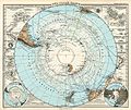
File:Stielers Handatlas 1891 07.jpg
Appearance

Size of this preview: 714 × 600 pixels. Other resolutions: 286 × 240 pixels | 571 × 480 pixels | 914 × 768 pixels | 1,219 × 1,024 pixels | 2,438 × 2,048 pixels | 4,999 × 4,200 pixels.
Original file (4,999 × 4,200 pixels, file size: 5.17 MB, MIME type: image/jpeg)
File history
Click on a date/time to view the file as it appeared at that time.
| Date/Time | Thumbnail | Dimensions | User | Comment | |
|---|---|---|---|---|---|
| current | 10:31, 23 January 2010 |  | 4,999 × 4,200 (5.17 MB) | Kolossos | better quality |
| 17:26, 21 November 2006 |  | 3,750 × 3,150 (1,020 KB) | Poccil | {{Stielers Handatlas 1891|06|08|Süd-Polar-Karte|South polar map}} Category:Old maps of Antarctica |
File usage
The following page uses this file:
Global file usage
The following other wikis use this file:
- Usage on ast.wikipedia.org
- Usage on de.wikipedia.org
- Usage on es.wikipedia.org
- Usage on fr.wikipedia.org
- Usage on it.wikipedia.org
- Usage on ja.wikipedia.org
- Usage on mk.wikipedia.org
- Usage on ru.wikipedia.org
- Usage on uk.wikipedia.org


