
File:Tanezrouft Basin ESA22416295.jpeg

Original file (10,980 × 8,726 pixels, file size: 17.38 MB, MIME type: image/jpeg)
| This is a file from the Wikimedia Commons. Information from its description page there is shown below. Commons is a freely licensed media file repository. You can help. |
Summary
| Warning | The original file is very high-resolution. It might not load properly or could cause your browser to freeze when opened at full size. |
|---|
| Description |
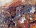
English: The Copernicus Sentinel-2 mission takes us over the Tanezrouft Basin – one of the most desolate parts of the Sahara Desert. Zoom in to see this image at its full 10 m resolution or click on the circles to learn more about the features in this image. Tanezrouft is a region of the Sahara lying in southern Algeria and northern Mali. The hyperarid area is known for its soaring temperatures and scarce access to water and vegetation, a reason why it’s often referred to as the ‘Land of Terror’. There are no permanent residents that live here, only occasional Tuareg nomads. The barren plain extends to the west of the Hoggar mountains and southeast of the sandy Erg Chech. The terrain shows evidence of water erosion that occurred many years ago, when the Sahara Desert’s climate was much wetter, as well as wind erosion caused by frequent sandstorms – exposing ancient folds in the Paleozoic rocks. The region is characterised by dark sandstone hills, steep canyon walls, salt flats (visible in white in the image), stone plateaus and seas of multi-storey sand dunes known as ‘ergs’. Concentric rings of exposed sandstone strata create a stunning pattern predominantly visible in the left of the image. White lines in the right of the image are roads that lead to In Salah – the capital of the In Salah Province and In Salah District. Just above the centre-left of the image, an airstrip can be seen. An interesting, grid-like pattern can be seen in the bottom of the image and mostly consists of human-made clearings and roads. This image, also featured on the Earth from Space video programme, was captured on 12 January 2020 by the Copernicus Sentinel-2 mission – a two-satellite mission to supply the coverage and data delivery needed for Europe’s Copernicus programme. |
| Date | 15 January 2021 (upload date) |
| Source | Tanezrouft Basin |
| Author | European Space Agency |
| Other versions |
|
| Activity | Observing the Earth |
| Mission | Sentinel-2 |
| Set | Earth observation image of the week |
| System | Copernicus |
Licensing

|
This image contains data from a satellite in the Copernicus Programme, such as Sentinel-1, Sentinel-2 or Sentinel-3. Attribution is required when using this image.
Attribution: Contains modified Copernicus Sentinel data 2020
The use of Copernicus Sentinel Data is regulated under EU law (Commission Delegated Regulation (EU) No 1159/2013 and Regulation (EU) No 377/2014). Relevant excerpts:
Free access shall be given to GMES dedicated data [...] made available through GMES dissemination platforms [...].
Access to GMES dedicated data [...] shall be given for the purpose of the following use in so far as it is lawful:
GMES dedicated data [...] may be used worldwide without limitations in time.
GMES dedicated data and GMES service information are provided to users without any express or implied warranty, including as regards quality and suitability for any purpose. |
This media was created by the European Space Agency (ESA).
Where expressly so stated, images or videos are covered by the Creative Commons Attribution-ShareAlike 3.0 IGO (CC BY-SA 3.0 IGO) licence, ESA being an Intergovernmental Organisation (IGO), as defined by the CC BY-SA 3.0 IGO licence. The user is allowed under the terms and conditions of the CC BY-SA 3.0 IGO license to Reproduce, Distribute and Publicly Perform the ESA images and videos released under CC BY-SA 3.0 IGO licence and the Adaptations thereof, without further explicit permission being necessary, for as long as the user complies with the conditions and restrictions set forth in the CC BY-SA 3.0 IGO licence, these including that:
See the ESA Creative Commons copyright notice for complete information, and this article for additional details.
|
 | |
This file is licensed under the Creative Commons Attribution-ShareAlike 3.0 IGO license. Attribution: ESA, CC BY-SA IGO 3.0
| ||
| Annotations | This image is annotated: View the annotations at Commons |
File history
Click on a date/time to view the file as it appeared at that time.
| Date/Time | Thumbnail | Dimensions | User | Comment | |
|---|---|---|---|---|---|
| current | 11:08, 15 January 2021 | | 10,980 × 8,726 (17.38 MB) | OptimusPrimeBot | #Spacemedia - Upload of https://www.esa.int/var/esa/storage/images/esa_multimedia/images/2021/01/tanezrouft_basin/22416285-1-eng-GB/Tanezrouft_Basin.jpg via Commons:Spacemedia |
File usage
The following page uses this file:
Global file usage
The following other wikis use this file:
- Usage on de.wikipedia.org
- Usage on fi.wikipedia.org
- Usage on fr.wikipedia.org
- Usage on lt.wikipedia.org