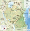
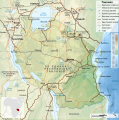
File:Tanzania relief location map.svg
Appearance

Size of this PNG preview of this SVG file: 630 × 600 pixels. Other resolutions: 252 × 240 pixels | 504 × 480 pixels | 807 × 768 pixels | 1,076 × 1,024 pixels | 2,152 × 2,048 pixels | 3,302 × 3,143 pixels.
Original file (SVG file, nominally 3,302 × 3,143 pixels, file size: 3.1 MB)
File history
Click on a date/time to view the file as it appeared at that time.
| Date/Time | Thumbnail | Dimensions | User | Comment | |
|---|---|---|---|---|---|
| current | 20:32, 3 March 2020 |  | 3,302 × 3,143 (3.1 MB) | Sémhur | Modifying Tanzanian border claim (from https://www.nbs.go.tz/index.php/en/census-surveys/gis/385-2012-phc-shapefiles-level-one-and-two) |
| 20:18, 28 June 2017 |  | 3,302 × 3,143 (3.09 MB) | Sémhur | Update with Songwe region | |
| 14:11, 28 December 2013 |  | 3,096 × 2,947 (3.1 MB) | Sémhur | Updated with the four new regions | |
| 15:17, 3 May 2009 |  | 3,096 × 2,947 (3.55 MB) | Sémhur | Adding border between Arusha and Manyara | |
| 18:58, 1 May 2009 |  | 3,096 × 2,947 (3.54 MB) | Sémhur | {{int:summary}} {{Information |Description={{en|1=Relief location map of en:Tanzania.}} {{fr|1=Carte de géolocalisation du relief de la fr:Tanzanie.}} {{es|1=Mapa de georreferenciación de es:Tanzania.}} Equirectangular projection. 0.25� |
File usage
More than 100 pages use this file. The following list shows the first 100 pages that use this file only. A full list is available.
- 2005 Lake Tanganyika earthquake
- Abeid Amani Karume International Airport
- Amani Nature Reserve
- Amboni Caves
- Arusha
- Arusha National Park
- Bank of Tanzania
- Benjamin Mkapa Stadium
- Bongoyo Island
- Bukoba
- Bukoba Airport
- Butiama
- Chumbe Island
- Churamiti
- Dar es Salaam
- Dar es Salaam Marine Reserve
- Dodoma
- Engaruka
- Fungu Yasini Island
- Furtwängler Glacier
- Gombe Stream National Park
- Hale Dam
- Hombolo Dam
- Hyperolius kihangensis
- Ikama
- Ikolo
- Ipinda
- Isange
- Kalambo Falls
- Kashasha
- Katavi National Park
- Kidatu Dam
- Kigoma
- Kihansi Hydroelectric Power Station
- Kilimanjaro International Airport
- Kilimanjaro National Park
- Kizimkazi Mosque
- Kondoa Rock-Art Sites
- Korogwe
- Laetoli
- Lake Eyasi
- Lake Manyara
- Lake Manyara National Park
- Lake Natron
- Lake Ngozi
- Lake Rukwa
- Lindi
- Lusungo
- Machame
- Mafia Channel
- Mafia Island
- Mahale Mountains National Park
- Makwale
- Manza Bay
- Matema
- Mbeya
- Mbudya Island
- Menai Bay
- Mikindani
- Misungwi
- Mkomazi National Park
- Mnazi Bay-Ruvuma Estuary Marine Park
- Morogoro
- Moshi, Tanzania
- Mount Kilimanjaro
- Mount Meru (Tanzania)
- Mtera Dam
- Mtwara
- Mumba Cave
- Mwanza
- Mwanza Airport
- Mwaya
- Nectophrynoides laticeps
- Nectophrynoides poyntoni
- Ngorongoro Conservation Area
- Nyumba ya Mungu Dam
- Olduvai Gorge
- Oyster Bay, Tanzania
- Pangani Falls Dam
- Pangavini Island
- Pemba Island
- Rebmann Glacier
- Ruaha National Park
- Saadani National Park
- Selous Game Reserve
- Serengeti National Park
- Shinyanga
- Shirati
- Songea
- Stone Town
- Sumbawanga
- Sumve
- Tabora
- Tanga Island
- Tarangire National Park
- Tendaguru Formation
- Tongoni Ruins
- Tukuyu
- Udzungwa Mountains
- Ujiji
View more links to this file.
Global file usage
The following other wikis use this file:
- Usage on af.wikipedia.org
- Usage on als.wikipedia.org
- Usage on ar.wikipedia.org
- Usage on ast.wikipedia.org
- Usage on as.wikipedia.org
- Usage on avk.wikipedia.org
- Usage on av.wikipedia.org
- Usage on azb.wikipedia.org
- Usage on az.wikipedia.org
- Usage on ban.wikipedia.org
- Usage on ba.wikipedia.org
View more global usage of this file.


