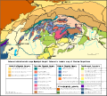
File:Tect Map West Carp.svg
Appearance

Size of this PNG preview of this SVG file: 643 × 579 pixels. Other resolutions: 267 × 240 pixels | 533 × 480 pixels | 853 × 768 pixels | 1,137 × 1,024 pixels | 2,274 × 2,048 pixels.
Original file (SVG file, nominally 643 × 579 pixels, file size: 238 KB)
File history
Click on a date/time to view the file as it appeared at that time.
| Date/Time | Thumbnail | Dimensions | User | Comment | |
|---|---|---|---|---|---|
| current | 11:11, 26 January 2017 |  | 643 × 579 (238 KB) | Maproom | Replaced fonts "Arial" and "Arial Black" by "Liberations Sans" throughout, and made the smallest two text sizes larger |
| 22:16, 26 July 2011 |  | 643 × 579 (238 KB) | Ciaurlec | Cropped | |
| 16:55, 10 February 2010 |  | 1,052 × 744 (280 KB) | Pelex | {{Information |Description={{en|1=Tectonic map of Western Carpathians}} {{sk|1=Tektonická mapa Západných Karpát}} |Source={{own}} |Author=Pelex |Date=2010-02-10 |Permission= |other_versions= }} Category:Geology of Slovakia [[Catego |
File usage
The following page uses this file:
Global file usage
The following other wikis use this file:
- Usage on pl.wikipedia.org
- Usage on pt.wikipedia.org
- Usage on uk.wikipedia.org

