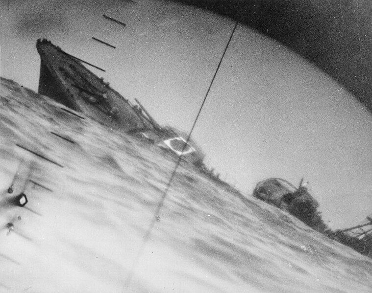
File:Torpedoed Japanese destroyer Yamakaze sinking on 25 June 1942.jpg
Appearance

Size of this preview: 759 × 599 pixels. Other resolutions: 304 × 240 pixels | 608 × 480 pixels | 973 × 768 pixels | 1,280 × 1,011 pixels | 2,560 × 2,021 pixels | 2,937 × 2,319 pixels.
Original file (2,937 × 2,319 pixels, file size: 3.84 MB, MIME type: image/jpeg)
| This is a featured picture, which means that members of the community have identified it as one of the finest images on the English Wikipedia, adding significantly to its accompanying article. If you have a different image of similar quality, be sure to upload it using the proper free license tag, add it to a relevant article, and nominate it. |
| This image was selected as picture of the day on the English Wikipedia for June 25, 2018. |
File history
Click on a date/time to view the file as it appeared at that time.
| Date/Time | Thumbnail | Dimensions | User | Comment | |
|---|---|---|---|---|---|
| current | 06:37, 9 October 2016 |  | 2,937 × 2,319 (3.84 MB) | Cobatfor | new NHHC file |
| 20:55, 21 August 2007 |  | 2,985 × 2,048 (1.5 MB) | BrokenSphere | == Summary == {{Information |Description=Torpedoed Japanese destroyer photographed through periscope of U.S.S. Wahoo or U.S.S. Nautilus, June 1942. (Navy) Exact Date Shot Unknown NARA FILE #: 080-G-418331 WAR & CONFLICT BOOK #: 1315 |Source=High resolutio |
File usage
The following 21 pages use this file:
- Allied submarines in the Pacific War
- Japanese destroyer Yamakaze (1936)
- List of maritime disasters in World War II
- List of shipwrecks in June 1942
- Pacific War
- Periscope
- Salmon-class submarine
- USS Nautilus (SS-168)
- Talk:Japanese destroyer Yamakaze (1936)
- User:Hughseyfort/sandbox
- User talk:TomStar81/Archive 17
- Wikipedia:Featured picture candidates/April-2015
- Wikipedia:Featured picture candidates/The death of the Imperial Japanese Destroyer Yamakaze as seen through the periscope of the submarine USS Nautilus (SS-168)
- Wikipedia:Featured pictures/History/World War II
- Wikipedia:Featured pictures thumbs/51
- Wikipedia:Main Page history/2018 June 25
- Wikipedia:Picture of the day/June 2018
- Wikipedia:WikiProject Military history/News/May 2015/Articles
- Wikipedia:Wikipedia Signpost/2015-04-15/Featured content
- Wikipedia:Wikipedia Signpost/Single/2015-04-15
- Template:POTD/2018-06-25
Global file usage
The following other wikis use this file:
- Usage on ar.wikipedia.org
- Usage on azb.wikipedia.org
- Usage on bg.wikipedia.org
- Usage on bn.wikipedia.org
- Usage on ca.wikipedia.org
- Usage on cs.wikipedia.org
- Usage on es.wikipedia.org
- Usage on eu.wikipedia.org
- Usage on fa.wikipedia.org
- Usage on fi.wikipedia.org
- Usage on fr.wikipedia.org
- Usage on hu.wikipedia.org
- Usage on id.wikipedia.org
- Usage on it.wikipedia.org
- Usage on ja.wikipedia.org
- Usage on ko.wikipedia.org
- Usage on nl.wikipedia.org
- Usage on pl.wikipedia.org
- Usage on pnb.wikipedia.org
- Usage on pt.wikipedia.org
- Usage on ru.wikipedia.org
- Usage on sl.wikipedia.org
- Usage on sr.wikipedia.org
- Usage on tg.wikipedia.org
- Usage on ur.wikipedia.org
- Usage on vi.wikipedia.org
- Usage on www.wikidata.org
- Usage on zh.wikipedia.org


