Jump to content

File:Welsh 2003 non-administrative counties flood damage July 24 2007.png

Page contents not supported in other languages.
This is a file from the Wikimedia Commons
From Wikipedia, the free encyclopedia

Original file (882 × 992 pixels, file size: 34 KB, MIME type: image/png)

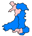
Description This image indicates in blue the preserved counties of Wales (as per Preserved Counties (Amendment to Boundaries) (Wales) Order 2003) affected by the 2007 floods as of July 24th 2007. That's Clwyd, Dyfed, Gwent, Powys, and South Glamorgan. Apologies if left any out. Some areas with only minor damage have been omitted. To forestall criticism, citations for each and every one of these areas can be found on http://en.wikipedia.org/w/index.php?title=2007_United_Kingdom_floods&oldid=149856883 under "Affected areas in Wales". The light blue colour was chosen because of its natural association with water, and pink as its opposite on the colour wheel. No other meaning is implied or should be inferred.
Date
Source This image was created by me in Microsoft Paint (don't laugh) on 2007-08-08 using http://en.wikipedia.org/wiki/Image:Wales1996Blank.png by User:Morwen as a template (that template had on 2007-08-08 the same GFDL license as this image).
Author Anameofmyveryown
Permission
(Reusing this file)
w:en:Creative Commons
attribution share alike
This file is licensed under the Creative Commons Attribution-Share Alike 3.0 Unported license. Subject to disclaimers.
You are free:
  • to share – to copy, distribute and transmit the work
  • to remix – to adapt the work
Under the following conditions:
  • attribution – You must give appropriate credit, provide a link to the license, and indicate if changes were made. You may do so in any reasonable manner, but not in any way that suggests the licensor endorses you or your use.
  • share alike – If you remix, transform, or build upon the material, you must distribute your contributions under the same or compatible license as the original.
This licensing tag was added to this file as part of the GFDL licensing update.
GNU head Permission is granted to copy, distribute and/or modify this document under the terms of the GNU Free Documentation License, Version 1.2 or any later version published by the Free Software Foundation; with no Invariant Sections, no Front-Cover Texts, and no Back-Cover Texts. A copy of the license is included in the section entitled GNU Free Documentation License. Subject to disclaimers.

Captions

Add a one-line explanation of what this file represents

Items portrayed in this file

depicts

17 September 2007

File history

Click on a date/time to view the file as it appeared at that time.

Date/TimeThumbnailDimensionsUserComment
current01:41, 18 September 2007Thumbnail for version as of 01:41, 18 September 2007882 × 992 (34 KB)Anameofmyveryown{{Information |Description=This image indicates in blue the [http://en.wikipedia.org/wiki/Preserved_counties_of_Wales preserved counties] of Wales (as per Preserved Counties (Amendment to Boundaries) (Wales) Order 2003) affected by the 2007 floods as of J

The following 2 pages use this file: