
Mahameghavahana dynasty
Maha-Meghavahana Dynasty Mahāmēghabāhana | |||||||||||||||
|---|---|---|---|---|---|---|---|---|---|---|---|---|---|---|---|
| 2nd or 1st century BC–4th century CE | |||||||||||||||
 Map of the Maha-Meghavahanas, circa 20 BCE.[1] | |||||||||||||||
| Capital | Toshali Kalinganagara | ||||||||||||||
| Common languages | Ardhamagadhi Prakrit (official, court, Inscriptions). Sanskrit (Literature) | ||||||||||||||
| Religion | Jainism | ||||||||||||||
| Government | Monarchy | ||||||||||||||
| Historical era | Classical India | ||||||||||||||
• Established | 2nd or 1st century BC | ||||||||||||||
• Disestablished | 4th century CE | ||||||||||||||
| |||||||||||||||

50 CE
| History of South Asia |
|---|
_without_national_boundaries.svg) |
The Mahameghavahana dynasty (Mahā-Mēgha-Vāhana, 2nd or 1st century BC to early 4th century CE[3][4]) was an ancient ruling dynasty of Kalinga after the decline of the Maurya Empire.[5] In the first century B.C., Mahameghavahana, a king of Chedirastra (or Cetarattha, i.e., kingdom of the Chedis)[6] conquered Kalinga and Kosala. During the reign of Kharavela, the third king of Mahameghavahana dynasty, South Kosala became an integral part of the kingdom. He patronised Jainism, but did not discriminate against other religions.[7][8] He is known by his Hathigumpha inscription.
South Kosala was later conquered by Gautamiputra Satakarni of the Satavahana dynasty in the early part of the 2nd century CE and remained in their possession up to the second half of the 2nd century CE. It was during the second and third century CE, the Meghas or Meghavahanas reappeared in the political scene and regained their suzerainty over South Kosala. Samudragupta during his Dakshinapatha expedition, defeated Mahendra of Dakshina Kosala who probably belonged to the Megha dynasty according to a speculation. As a result, the South Kosala during the fourth century A.D, became a part of the Gupta empire.[3][9]
List of rulers
[edit]
The Hathigumpha inscription describes the following rulers.[10] It does not directly mention the relationship between Mahameghavahana and Kharavela, or the number of kings between them.[11] Some historians have interpreted the inscription to create the following hypothetical family tree:[10]
| Lalaka | |||||||||||||||||||||||
| Khemaraja (a.k.a. Kshemaraja) | Unknown | ||||||||||||||||||||||
| Vudharaja (a.k.a. Vriddharaja) | Hastisaha (a.k.a. Hastisimha) | ||||||||||||||||||||||
| Kharavela (a.k.a. Bhiku, Bhikshuraja) | Daughter | ||||||||||||||||||||||
| Vakradeva (a.k.a. Kudepasiri) | |||||||||||||||||||||||
| Vadukha (a.k.a. Badukha) | |||||||||||||||||||||||
Kharavela
[edit]The third ruler of the dynasty, Khārabēḷa, conquered much of India in a series of campaigns at the beginning of the common era. Kaḷingan military might was reinstated by Khārabēḷa: under Khārabēḷa's generalship, the Kaḷinga state had a formidable maritime reach with trade routes linking it to the then-Simhala (Sri Lanka), Burma (Myanmar), Siam (Thailand), Vietnam, Kamboja (Cambodia), Borneo, Bali, Samudra (Sumatra) and Jabadwipa (Java). Khārabēḷa led many successful campaigns against the states of Magadha, Anga, the Satavahanas and the South Indian regions ruled by the Pandyan dynasty (modern Andhra Pradesh) and expanded Kaḷinga as far as the Ganges and the Kaveri.[5][10]
The Kharavelan state had a formidable maritime empire with trading routes linking it to Sri Lanka, Burma, Thailand, Vietnam, Cambodia, Borneo, Bali, Sumatra and Java. Colonists from Kaḷinga settled in Sri Lanka, Burma, as well as the Maldives and Maritime Southeast Asia. Even today Indians are referred to as Keling in Malaysia because of this.[7][12]
Although religiously tolerant, Khārabēḷa patronised Jainism, and was responsible for the propagation of Jainism in the Indian subcontinent but his importance is neglected in many accounts of Indian history. The main source of information about Khārabeḷa is his famous seventeen line rock-cut Hātigumphā inscription in the Udayagiri and Khandagiri Caves near Bhubaneswar, Odisha. According to the Hathigumpha inscription, he attacked Rajagriha in Magadha, thus inducing the Indo-Greek king Demetrius I of Bactria to retreat to Mathura.[10][12]
Branches of Mahameghavahana Dynasty
[edit]The Sada dynasty who ruled form Amaravati region in their inscription from Guntapalli describe themselves as Maharaja of Kalinga Mahisaka countries belonging to Mahameghavahana family.[13]

Meghas of Dakshina Kosala -During the reign of Kharavela, the third king of Mahameghavahana dynasty, South Kosala became an integral part of the Kalinga,from there originated the Kosala branch of the Mahameghavahana dynasty.[14][12]
Mahendra a king of Dakshina Kosala,was often identified with the Meghas of Kosala, who ruled over Kosala from the 3rd century AD to the 6th century AD.[4][3]
Architecture
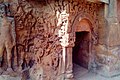
[edit]Udayagiri and Khandagiri Caves is the most prominent example of Mahameghavahana dynasty work. These caves were built in 2nd century BCE during the rule of King Kharavela. Udayagiri means "Sunrise Hill" and has 18 caves while Khandagiri (means "Broken Hill") has 15 caves. The Hathigumpha cave ("Elephant Cave") has the Hathigumpha inscription, written by Raja Kharavela, the king of Kalinga in India, during the 2nd century BCE. The Hathigumpha inscription consists of seventeen lines incised in deep cut Brahmi letters starting with Jain Namokar Mantra. In Udayagiri, Hathigumpha (cave 14) and Ganeshagumpha (cave 10) are especially well known due to art treasures of their sculptures and reliefs as well as due to their historical importance. Rani ka Naur (Queen's Palace cave, cave 1) is also an extensively carved cave and elaborately embellished with sculptural friezes. Khandagiri offers a fine view back over Bhubaneswar from its summit. The Ananta cave (cave 3) depicts carved figures of women, elephants, athletes, and geese carrying flowers.[10]
-

-
 Hathigumpha inscription
 -
 Yavanaraja Dimita inscription at Hathigumpha
 -
 Brahmi script Inscription of King Kharavela
 -
 Carvings on Udayagiri Caves
 -
 Door Carving of Ancient Caves, Udaygiri and Khandagiri Hills, Jagmara, Odisha.
 -
 Khandagiri and Udaygiri Caves6
 -
 KHANDAGIRI AND UDAYGIRI CAVES 8
 -
 Udaygiri and Khandagiri Cave - 2
 -
 Udaygiri and Khandagiri Cave - 3.
 -
 Door and arch in Udaygiri caves
 -


.jpg)

.JPG)


References
[edit]- ^ Schwartzberg, Joseph E. (1978). A Historical atlas of South Asia. Chicago: University of Chicago Press. p. 145, map XIV.1 (f). ISBN 0226742210.
- ^ Schwartzberg, Joseph E. (1978). A Historical atlas of South Asia. Chicago: University of Chicago Press. p. 21, 145. ISBN 0226742210.
- ^ a b c Sahu, J. K. (1977). "The Meghas of Kosala". Proceedings of the Indian History Congress. 38: 49–54. ISSN 2249-1937. JSTOR 44139050.
- ^ a b Sahu, J.K. (1977). "The Meghas of Kosala" (PDF). shodhganga.
- ^ a b For a map of their territory see: Schwartzberg, Joseph E. (1978). A Historical atlas of South Asia. Chicago: University of Chicago Press. p. 145, map XIV.1 (f). ISBN 0226742210.
- ^ L Bhagawandas Gandhi (1927). Tribes in Ancient India.
- ^ a b Hampa Nagarajaiah (1999). A History of the Early Ganga Monarchy and Jainism. Ankita Pustaka. p. 10. ISBN 978-81-87321-16-3.
- ^ Kailash Chand Jain (2010). History of Jainism. D. K. Print World (P) Limited. p. 437. ISBN 978-81-246-0547-9.
- ^ Sahu, J.K. "The Meghas of Kosala" (PDF). shodhganga.
- ^ a b c d e Bhagwanlal Indraji (1885). "The Hâtigumphâ and three other inscriptions in the Udayagiri caves near Cuttack". Proceedings of the Leyden International Oriental Congress for 1883. pp. 144–180.
- ^ Sailendra Nath Sen (1999). Ancient Indian History and Civilization. New Age International. pp. 176–177. ISBN 978-81-224-1198-0.
- ^ a b c N. K.Sahu, M. A. (1964). Utkal University History Of Orissa. Servants of Knowledge. The Utkal University.
- ^ Shimada, Akira (9 November 2012). Early Buddhist Architecture in Context: The Great St?pa at Amar?vat? (ca. 300 BCE-300 CE). BRILL. ISBN 978-90-04-23283-9.
- ^ Patnaik, Jeeban Kumar (1998). "Temples of South Kosala 6th century A D 11th century A D a case study of stellate temples". University.
