Queshuachaca
Queshuachaca Q’ichwa Chaka | |
|---|---|
 Queshuachaca bridge | |
| Coordinates | 14°22′53″S 71°29′02″W / 14.381315°S 71.484008°W |
| Carries | Pedestrians |
| Crosses | Apurímac River |
| Locale | Quehue District, Peru |
| Characteristics | |
| Design | Inca rope bridge |
| Material | Ichu grass |
| Total length | 28 metres (92 ft) |
| Width | 1.2 metres (3 ft 11 in) |
| Location | |
 | |
| Knowledge, skills and rituals related to the annual renewal of the Q'eswachaka bridge | |
|---|---|
| Country | Peru |
| Reference | 00594 |
| Region | Latin America and the Caribbean |
| Inscription history | |
| Inscription | 2013 (8th session) |
| List | Representative |
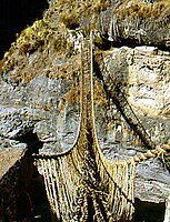
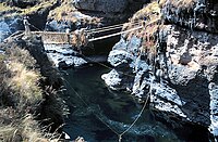
Queshuachaca[Note 1] (from Cuzco Quechua q’ichwa chaka 'straw-rope bridge', Quechua pronunciation: [q’es.wa cha.ka]) is the last remaining Inca rope bridge, consisting of grass ropes that span the Apurímac River near Huinchiri, in Quehue District, Canas Province, Peru.[1]
Even though there is a modern bridge nearby, the residents of the region keep the ancient tradition and skills alive by renewing the bridge annually, during the second week of June.[2] Several family groups from the communities of Chaupibanda, Choccayhua, Huinchiri and Collana Quehue, have each prepared a number of grass-ropes to be formed into cables at the site, others prepare mats for decking, and the reconstruction is a communal effort. In ancient times the effort would have been a form of tax (Mit'a), with participants expected to perform the rebuilding; nowadays the builders have indicated that effort is performed to honor their ancestors and the Pachamama (Earth Mother).[citation needed]
The event has also been supported by video productions for Nova and the BBC and is the subject of an independent documentary titled The Last Bridge Master (in-production, 2014). It is becoming a minor tourist attraction, with some small tolls charged for tourists to use the road during the festival to walk the newly completed bridge. In 2009 the government recognized the bridge and its maintenance as part of the cultural heritage of Peru, and there is now some outside sponsorship.[3][non-tertiary source needed] The lead bridge engineer was Victoriano Arizapana.[citation needed]
Due to a lack of maintenance during the COVID-19 pandemic in 2020 and early 2021, the bridge collapsed in March 2021. In the following weeks the bridge was rebuilt.[4]
Renewing the bridge
[edit]-
The Q'eswachaka bridge
-
The sagging old bridge
(Slide show) -
The new bridge
-
Builders gather during the renewal
-
Preparing side lashings
-
Main cable and hand-ropes are in place
-
Lashing the hand-ropes to the main side cables.
-
Trimmed mat rolls form the bridge deck.
-
The new bridge is now complete and in use.
-
Bridge in use during the rainy season.
Notes
[edit]- ^ The name gets spelled very differently, mostly with the first element varying between <Q'eswa ~ Q'iswa ~ Queshua ~ Quishua> and the second between <Chaka ~ Chaca>. The first element is often confused with Quechua qichwa 'temperate valley; Quechua (people or language)', which is variously spelled <qhichwa ~ qhechwa ~ quechua ~ qheswa ~ qhiswa ~ keswa ~ keshwa>, among others.
References
[edit]- ^ "The Last Incan Grass Bridge", Joshua Foer, February 22, 2011, slate.com
- ^ The Last Inca bridge, Andean culture and engineering, 15th July 2019, we robotics.org
- ^ (automated translation) of http://globedia.com/inc-declara-patrimonio-cultural-inmaterial-puente-eswachaka-cusco
- ^ Bridge made of string: Peruvians weave 500-year-old Incan crossing back into place, the guardian.com, 16 June 2021.
External links
[edit]- The Bridge at Q’eswachaka - YouTube (duration—3:15; produced by the Smithsonian Institution)


