Chuhuiv Raion
Chuhuiv Raion
Чугуївський район | |
|---|---|
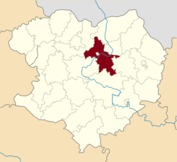
 Raion location in Kharkiv Oblast | |
| Coordinates: 49°46′59.5308″N 36°45′24.858″E / 49.783203000°N 36.75690500°E | |
| Country | |
| Oblast | |
| Admin. center | Chuhuiv |
| Subdivisions | 9 hromadas |
| Area | |
• Total | 4,804 km2 (1,855 sq mi) |
| Population (2022)[2] | |
• Total | 194,177 |
| • Density | 40/km2 (100/sq mi) |
| Time zone | UTC+2 (EET) |
| • Summer (DST) | UTC+3 (EEST) |
| Website | chuguevrda |
Chuhuiv Raion (Ukrainian: Чугуївський район) is a raion (district) in Kharkiv Oblast, Ukraine. Its administrative center is the city of Chuhuiv. Population: 194,177 (2022 estimate).[2]
On 18 July 2020, as part of the administrative reform of Ukraine, the number of raions of Kharkiv Oblast was reduced to seven, and the area of Chuhuiv Raion was significantly expanded. Three abolished raions, Pechenihy, Vovchansk, and Zmiiv Raions, as well as the city of Chuhuiv, which was previously incorporated as a city of oblast significance and did not belong to the raion, were merged into Chuhuiv Raion.[3][4][5] The January 2020 estimate of the raion population was 45,362 (2020 est.).[6]
Subdivisions
[edit]Current
[edit]After the reform in July 2020, the raion consisted of 9 hromadas:[5]
- Chkalovske settlement hromada with the administration in the rural settlement of Prolisne, retained from Chuhuiv Raion;
- Chuhuiv urban hromada, transferred from Chuhuiv Municipality;[7]
- Malynivka settlement hromada with the administration in the rural settlement of Malynivka, retained from Chuhuiv Raion;
- Novopokrovka settlement hromada with the administration in the rural settlement of Novopokrovka, retained from Chuhuiv Raion;
- Pechenihy settlement hromada with the administration in the rural settlement of Pechenihy, transferred from Pechenihy Raion;[8]
- Slobozhanske urban hromada with the administration in the city of Slobozhanske, transferred from Zmiiv Raion;[9]
- Staryi Saltiv settlement hromada with the administration in the rural settlement of Staryi Saltiv, transferred from Vovchansk Raion;[10]
- Vovchansk urban hromada with the administration in the city of Vovchansk, transferred from Vovchansk Raion;[10]
- Zmiiv urban hromada with the administration in the city of Zmiiv, transferred from Zmiiv Raion.[9]
Before 2020
[edit]
Before the 2020 reform, the raion consisted of three hromadas:[11]
- Chkalovske settlement hromada with the administration in Chkalovske;
- Malynivka settlement hromada with the administration in Malynivka;
- Novopokrovka settlement hromada with the administration in Novopokrovka.
Geography
[edit]The Chuhuiv Raion is located in the central and northern parts of the Kharkiv region. The Raion borders Russia (Belgorod Oblast).[12][13]
The territory of the Chuhuiv Raion is located on the Central Russian Upland and the Poltava Plain, within the forest steppe natural zone. The relief of the Chuhuiv Raion is an undulating plain with ravines and gullies.[14]
The climate of the Chuhuiv Raion is temperate continental with cold winters and hot summers. The average annual temperature is +8.7 °C (in January -4.5, in July +22). The average annual rainfall is 520 mm. The highest rainfall occurs in the summer. There are large forest areas (pine and deciduous trees) on the territory of the raion. The soils of the community are chernozems and meadow soils.[15][14]
The district is located in the Donets Valley. Lake Lyman, which is located in the district, is the largest natural lake in the Kharkiv region. [15] The Pecheneg Reservoir was created in the district on the Donets River, the dam of which was damaged as a result of shelling by Russian troops on September 20, 2022.[16]
Mineral resources of theChuhuiv Raion: loams, clays, sandstones, peat, natural gas.[13]
The territory of the community is crossed by a railway and national highways H26 and European route E-40, which runs from Izyum to Chuguiv.[17][18]
References
[edit]- ^ "Харківська область - Райони". decentralization.gov.ua. 2023-01-05. Archived from the original on 2023-01-05. Retrieved 2023-09-27.
- ^ a b Чисельність наявного населення України на 1 січня 2022 [Number of Present Population of Ukraine, as of January 1, 2022] (PDF) (in Ukrainian and English). Kyiv: State Statistics Service of Ukraine. Archived (PDF) from the original on 4 July 2022.
- ^ Where did 354 districts disappear to? Anatomy of loud reform, Glavcom (7 August 2020) (in Ukrainian) Retrieved 2020-10-03.
- ^ "Про утворення та ліквідацію районів. Постанова Верховної Ради України № 807-ІХ". Голос України (in Ukrainian). 2020-07-18. Retrieved 2020-10-03.
- ^ a b "Склад громади" (in Ukrainian). Міністерство розвитку громад та територій України. Retrieved 2020-10-03.
- ^ Чисельність наявного населення України на 1 січня 2020 року / Population of Ukraine Number of Existing as of January 1, 2020 (PDF) (in Ukrainian and English). Kyiv: State Statistics Service of Ukraine. Archived (PDF) from the original on 28 September 2023.
- ^ "Чугуевская городская громада" (in Russian). Портал об'єднаних громад України. Retrieved 2020-10-03.
- ^ "Печенізька районна рада (состав до 2020 г.)" (in Russian). Портал об'єднаних громад України. Retrieved 2020-10-03.
- ^ a b "Зміївська районна рада (состав до 2020 г.)" (in Russian). Портал об'єднаних громад України. Retrieved 2020-10-03.
- ^ a b "Вовчанська районна рада (состав до 2020 г.)" (in Russian). Портал об'єднаних громад України. Retrieved 2020-10-03.
- ^ "Чугуївська районна рада (состав до 2020 г.)" (in Russian). Портал об'єднаних громад України. Retrieved 2020-10-03.
- ^ Сегіда К. Ю., Редін В. І., Чабань М. Т. Географія Харківської області: «Економічна та соціальна географія». – Харків, 2012. – 56 с. Retrieved 2025-07-03
- ^ a b Харківська область. Географічний атлас. Серія «Моя мала Батьківщина» – 2021 рISBN 978-617-7208-58-6 Retrieved 2025-07-03
- ^ a b "Географія". Харківська обласна військова адміністрація (in Ukrainian). Retrieved 2025-07-03.
- ^ a b Харківська область. Географічний атлас. Серія «Моя мала Батьківщина» – 2021 р. ISBN 978-617-7208-58-6 Retrieved 2025-07-03
- ^ "російські загарбники зруйнували верхній шлюз Печенізької дамби". www.ukrinform.ua (in Ukrainian). 2022-09-21. Retrieved 2025-07-03.
- ^ Постанова Кабінету Міністрів України від 30 січня 2019 року № 55 «Про затвердження переліку автомобільних доріг загального користування державного значення» Retrieved 2025-07-03
- ^ UN Economic Commission for Europe: Overall Map of E-road Network (2007) Retrieved 2025-07-03


