
Cwm Prysor Viaduct
Cwm Prysor Viaduct | |
|---|---|
 Cwm Prysor Viaduct in 2014 | |
| Coordinates | 52°55′56″N 3°49′25″W / 52.9323°N 3.8235°W |
| Carries | Ex-Bala and Festiniog Railway |
| Crosses | Afon Prysor |
| Locale | Cwm Prysor, east of Trawsfynydd, Gwynedd, Wales |
| Official name | Cwm Prysor Viaduct |
| Characteristics | |
| Design | 9 36 feet (11 m) brick arches on stone piers[1][2] |
| Total length | 490 feet (150 m) |
| Width | Single Standard Gauge Rail |
| Height | 105 feet (32 m)[3] |
| History | |
| Opened | 1 November 1882[4] |
| Closed | 28 January 1961[5] |
| Statistics | |
| Daily traffic | Footpath |
| Location | |
 | |
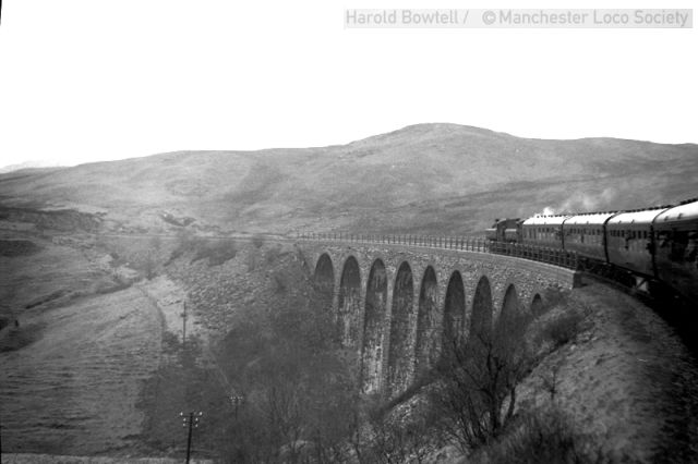
Cwm Prysor Viaduct, which is occasionally referred to as Blaen-y-Cwm Viaduct, is a railway viaduct which crosses the Afon Prysor in thinly populated uplands east of Trawsfynydd, Gwynedd, Wales. It was built by the Bala and Festiniog Railway. It carried a single track on a line that ran between Bala Junction and Blaenau Ffestiniog. The line it was built for went out of service in 1961.[6][7]
Bala & Festiniog Railway | |||||||||||||||||||||||||||||||||||||||||||||||||||||||||||||||||||||||||||||||||||||||||||||||||||||||||||||||||||||||||||||||||||||||||||||||||||||||||||||||||||||||||||||||||||||||||||||||||||||||||||||||||||||||||||||||||||||||||||||||||||||||||||||||||||||||||||||||||||||||
|---|---|---|---|---|---|---|---|---|---|---|---|---|---|---|---|---|---|---|---|---|---|---|---|---|---|---|---|---|---|---|---|---|---|---|---|---|---|---|---|---|---|---|---|---|---|---|---|---|---|---|---|---|---|---|---|---|---|---|---|---|---|---|---|---|---|---|---|---|---|---|---|---|---|---|---|---|---|---|---|---|---|---|---|---|---|---|---|---|---|---|---|---|---|---|---|---|---|---|---|---|---|---|---|---|---|---|---|---|---|---|---|---|---|---|---|---|---|---|---|---|---|---|---|---|---|---|---|---|---|---|---|---|---|---|---|---|---|---|---|---|---|---|---|---|---|---|---|---|---|---|---|---|---|---|---|---|---|---|---|---|---|---|---|---|---|---|---|---|---|---|---|---|---|---|---|---|---|---|---|---|---|---|---|---|---|---|---|---|---|---|---|---|---|---|---|---|---|---|---|---|---|---|---|---|---|---|---|---|---|---|---|---|---|---|---|---|---|---|---|---|---|---|---|---|---|---|---|---|---|---|---|---|---|---|---|---|---|---|---|---|---|---|---|---|---|---|---|---|---|---|---|---|---|---|---|---|---|---|---|---|---|---|---|---|---|---|---|---|---|---|---|---|---|---|---|---|---|---|---|
| |||||||||||||||||||||||||||||||||||||||||||||||||||||||||||||||||||||||||||||||||||||||||||||||||||||||||||||||||||||||||||||||||||||||||||||||||||||||||||||||||||||||||||||||||||||||||||||||||||||||||||||||||||||||||||||||||||||||||||||||||||||||||||||||||||||||||||||||||||||||
History
[edit]The structure consists of nine stone arches carrying a single bi-directional track over which passenger trains ran from 1882 to 1960, with freight trains lasting until 1961. The viaduct was the most substantial single structure on the line. It is sharply curved, necessitating the provision of a check rail in its active railway days.[8][9]
In 1953 extensive repair work was undertaken in which the opportunity was taken to raise the parapet and add metal railings on top.[10][11]
A "Last Train" special crossed the viaduct a week before final closure.[12][13] The track was lifted in the 1960s.
The prospect of rail traffic returning over the viaduct is very remote, not least because part of the route has been flooded by the construction of a dam at Llyn Celyn.
Modern access
[edit]The structure is Grade II Listed.[14] The landowner allows public access but there is no public right of way.[15]
References
[edit]- ^ Baughan 1991, p. 131.
- ^ Boyd 1959, p. 546.
- ^ The viaduct, via Forgotten Relics
- ^ Boyd 1988, p. 47.
- ^ Southern 1995, p. 64.
- ^ The viaduct on an Edwardian 6" OS map, via National Library of Scotland
- ^ The viaduct, via Rail Map Online
- ^ Green 1996, p. 38.
- ^ Southern, Leadbetter & Weatherley 1987, pp. 62–3.
- ^ Southern 1995, pp. 58–9.
- ^ Mitchell & Smith 2010, Photo 19.
- ^ "1961 last train at Bala, Arenig and Cwm Prysor Viaduct". NW Rail.
- ^ Gammell 1983, Plate 12.
- ^ "Viaduct over Nant y Lladron". British Listed Buildings. Retrieved 20 August 2018.
- ^ The viaduct, via flickr
Sources
[edit]- Baughan, Peter E. (1991) [1980]. A Regional History of the Railways of Great Britain: North and Mid Wales v. 11. Nairn: David St John Thomas Publisher. ISBN 978-0-946537-59-4.
- Boyd, James I.C. (October 1959). Mansell, K.G. (ed.). "Bala & Festiniog Section - W.R.". Railway World. 20 (233). London: Railway World Limited.
- Boyd, James I.C. (1988) [1972]. Narrow Gauge Railways in South Caernarvonshire – Volume 1. Headington: The Oakwood Press. ISBN 978-0-85361-365-7. OCLC 20417464.
- Gammell, Chris J. (1983). Around the Branch Lines. Poole: Oxford Publishing. ISBN 978-0-86093-213-0. No.2 Great Western.
- Green, C.C. (1996) [1983]. North Wales Branch Line Album. Shepperton: Ian Allan Publishing. ISBN 978-0-7110-1252-3.
- Mitchell, Vic; Smith, Keith (2010). Bala to Llandudno: Featuring Blaenau Ffestiniog. Midhurst: Middleton Press (MD). ISBN 978-1-906008-87-1.
- Southern, D. W. (1995). Bala Junction to Blaenau Ffestiniog. Scenes from the Past, Railways of North Wales. Stockport: Foxline Publishing. ISBN 978-1-870119-34-4. No. 25.
- Southern, D. W.; Leadbetter, H.J.; Weatherley, S.A. (1987). Rails to Bala. Rhuddlan: Charter Publications. ISBN 978-0-907157-03-8.
Further material
[edit]- Ferris, Tom (2004) [1961]. British Railways Volume 4 - Bewdley To Blaenau (DVD). demanddvd. DEMDVD084.
- Turner, Alun (2003). Gwynedd's Lost Railways. Catrine: Stenlake Publishing. ISBN 978-1-84033-259-9.
External links
[edit]- The line LJT2 with mileages Railway Codes
- Reminiscences by a local railwayman Forgotten Relics
- 1960 Working timetable 2D53
- Special train on the viaduct NW Rail