Ese Odo
Ese Odo | |
|---|---|
| Coordinates: 6°13′03″N 4°57′52″E / 6.2174°N 4.9645°E | |
| Country | |
| State | Ondo State |
| Time zone | UTC+1 (WAT) |
 | |
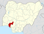
Ese Odo is a Local Government Area in Ondo State, Nigeria, populated by the Ijaw (Izon) ethnic sub groups of the Western Apoi tribe and the Arogbo tribe.[1] Its headquarters are in the town of Igbekebo and its one of the LGA with crude oil in Ondo State. The biggest towns within this Local Government Area are Kiribo,Arogbo,Ukparama(Akpata,Opuba,Ajapa,Ukpe,Bolowou), Igbobini, Igbotu,and Igbekebo.
Ese-Odo being mainly an Ijaw(Izon) ethnic subgroup in Ondo State, makes it the only local government that are Ijoid in the whole of South-West, as most falls into the South-South geo-political groupings in Nigeria. It has an area of 762 km2 and a population of 154,978 at the 2006 census and its one of the oil producing LGA in the State.[citation needed]
The postal code of the area is 352.[2] Notable people from Ese Odo LGA includes Come Sola Iji,Agboola Ajayi, Omoyele Sowore, Seun Botu (Engr) among others
References
[edit]- ^ "Communities In Ese Odo Area Of Ondo State Submerged In Natural Disaster". Sahara Reporters. 21 July 2014. Retrieved 8 April 2022.
- ^ "Post Offices- with map of LGA". NIPOST. Archived from the original on 7 October 2009. Retrieved 20 October 2009.
2. https://nigeriazipcodes.com/5965/list-of-towns-and-villages-in-ese-odo-lga/. Retrieved 2019-12-16.


