Fanandrana
Appearance
Fanandrana | |
|---|---|
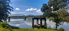
 Ivondro bridge at Fanandrana | |
| Coordinates: 18°11′40″S 49°22′45″E / 18.19444°S 49.37917°E | |
| Country | |
| Region | Atsinanana |
| District | Toamasina II |
| Area | |
• Total | 292 km2 (113 sq mi) |
| Elevation | 15 m (49 ft) |
| Population (2019)Census | |
• Total | 17,644 |
| Time zone | UTC3 (EAT) |
| Postal code | 501 |
Fanandrana is a rural commune in the district of Toamasina II (district), in the region of Atsinanana, on the east coast of Madagascar. It is situated at the National road RN 2 at 26 km from Toamasina. The Ivondro River flows through the center of Fanandrana, and the Fanandrana river in its south.
Economy
[edit]The economy is based on agriculture. Rice is grown, other crops are oil palms, manioc, cloves, sugar cane and pepper.[2][3]
In 2024 a prison of high security was inaugurated in Fanandrana, fokontany Antananambo.[4]
References
[edit]- ^ ETUDE DE LA COMMERCIALISATION DU SUCRE BIO ET SES PERSPECTIVES
- ^ "ANALYSE DE LA SITUATION DE LA CULTURE MARAÎCHERE DU LITTORAL CENTRE EST DE MADAGASCAR CAS DE LA COMMUNE RURALE DE FANANDRANA" (PDF). Archived from the original (PDF) on 2021-09-08. Retrieved 2021-09-08.
- ^ Tsimanadino Herilanto Jean Théodurant ANDRIATSITOHAINA (2011-04-27). "APPORTS DE LA POPULATION RURALE AU DÉVELOPPEMENT ÉCONOMIQUE (CAS DU DISTRICT DE TOAMASINA II)" (PDF). Retrieved 2021-09-08.
- ^ L'Express de Madagascar
Wikimedia Commons has media related to Fanandrana.


