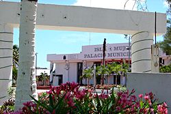
Isla Mujeres Municipality
Appearance
Isla Mujeres | |
|---|---|
 Municipal hall on Isla Mujeres | |
 Location of the Municipality in the State | |
| Coordinates: 21°14′N 86°44′W / 21.233°N 86.733°W | |
| Country | Mexico |
| State | Quintana Roo |
| Municipal seat | Isla Mujeres |
| Government | |
| • Municipal President[1] | Hugo Sánchez Montalvo |
| Area | |
| • Municipality | 1,100 km2 (400 sq mi) |
| Elevation | 1 m (3 ft) |
| Population (2010, 2019) | |
| • Municipality | 22,686 |
| • Urban | 15,295 |
| Time zone | UTC−5 (Southeastern Time Zone) |
| INEGI Code | 23003 |
| Website | www |
Isla Mujeres (Spanish pronunciation: ['isla mu'xeɾes], Spanish for Island of the Women) is one of the eleven municipalities of the Mexican state of Quintana Roo, located on the Yucatán Peninsula. Most of the municipality is located on the mainland in the northeastern corner of the state. Its municipal seat, also called Isla Mujeres, is a small town on the island from which it takes its name. It is located about 13 kilometres (8.1 mi) northeast of Cancún in the Caribbean Sea, and it is the easternmost municipal seat in Mexico. As of the 2010, 2019 census, the town had a population of 22,686 inhabitants.[3]
Towns and villages
[edit]The municipality consists of a total of 143 localities. The largest localities (cities, towns, and villages) are:[3]

| Name | Population (2010 Census) |
|---|---|
| Isla Mujeres | 12,642
|
| Zona Urbana Ejido Isla Mujeres | 2,653
|
| Francisco May | 223
|
| Punta Sam | 30
|
| Total municipality | 16,203 |
Demographics
[edit]| Year | Pop. | ±% p.a. |
|---|---|---|
| 1995 | 8,750 | — |
| 2000 | 11,313 | +5.27% |
| 2005 | 13,315 | +3.31% |
| 2010 | 16,203 | +4.00% |
| Source: INEGI Instituto Nacional de Estadística y Geografía[4] | ||
References
[edit]- ^ [1] Official Website for Isla Mujeres
- ^ Quintana Roo Archived 2014-10-14 at the Wayback Machine Enciclopedia de los Municipios de México
- ^ a b 2010 census tables: INEGI Archived 2013-05-02 at the Wayback Machine
- ^ INEGI. Instituto Nacional de Estadística y Geografía. Censo de Población y Vivienda 1995, 2000, 2005, 2010. Archived 2013-09-28 at the Wayback Machine
External links
[edit] Media related to Isla Mujeres Municipality at Wikimedia Commons
- Official website


