Jarrier
Jarrier | |
|---|---|
 The Saint-Roch Chapel in 2015 | |
| Coordinates: 45°16′52″N 6°19′03″E / 45.2811°N 6.3175°E | |
| Country | France |
| Region | Auvergne-Rhône-Alpes |
| Department | Savoie |
| Arrondissement | Saint-Jean-de-Maurienne |
| Canton | Saint-Jean-de-Maurienne |
| Government | |
| • Mayor (2020–2026) | Marc Picton[1] |
Area 1 | 17.79 km2 (6.87 sq mi) |
| Population (2021)[2] | 499 |
| • Density | 28/km2 (73/sq mi) |
| Time zone | UTC+01:00 (CET) |
| • Summer (DST) | UTC+02:00 (CEST) |
| INSEE/Postal code | 73138 /73300 |
| Elevation | 760–2,173 m (2,493–7,129 ft) |
| 1 French Land Register data, which excludes lakes, ponds, glaciers > 1 km2 (0.386 sq mi or 247 acres) and river estuaries. | |
Jarrier (French pronunciation: [ʒaʁje]; Arpitan: Jarriér) is a commune in the Savoie department in the Auvergne-Rhône-Alpes region in south-eastern France.
Geography
[edit]Climate
[edit]According to a 2010 study by the French National Centre for Scientific Research, the commune is situated in a "mountain climate".[3] In 2020, Météo-France published its own typology of French climates in which it categorized the commune's climate as a mountain climate or mountain margins climate within the Northern Alps climate region.[4]
From 1971 to 2000, the average annual temperature was 8.3 °C (46.9 °F), with an annual range of 17.4 °C (63.3 °F). The average annual rainfall was 1,156 millimetres (45.5 in), with 9.7 days of rainfall in January and 8.9 days of rainfall in July.[3]
-
Map of the commune's infrastructure and land use in 2018
-
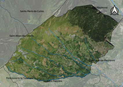
Satellite image of the commune
Demographics
[edit]According to France's National Institute of Statistics and Economic Studies, the commune had a population of 499 in 2021, up from 497 in 2015.[5] The age distribution was skewed towards the elderly, with 13.5% of the population aged 14 and under, 9.3% aged 15−29, 16% aged 30−44, 22.4% aged 45−59, 27.4% aged 60−74, and 11.5% aged 75 or higher. Since 2015, the population of the 60−74 and 75+ age ranges had increased while the younger age ranges had decreased in population.[5]
The commune had 153 single-family households, 56.1% of which were couples without children. 37.3% were couples with children, and a further 6.6% were single-parent households. 87.8% of permanent residences were owned by their occupants, while 9.7% were rented. The median disposable household income was €26,000.[5]
See also
[edit]References
[edit]- ^ "Répertoire national des élus: les maires". data.gouv.fr, Plateforme ouverte des données publiques françaises (in French). 2 December 2020.
- ^ "Populations légales 2021" (in French). The National Institute of Statistics and Economic Studies. 28 December 2023.
- ^ a b Daniel Joly, Thierry Brossard, Hervé Cardot, Jean Cavailhes, Mohamed Hilal et Pierre Wavresky (18 June 2010), "Les types de climats en France, une construction spatiale", Cybergéo, revue européenne de géographie - European Journal of Geography (in French), no. 501, doi:10.4000/cybergeo.23155, retrieved 29 July 2024
{{citation}}: CS1 maint: multiple names: authors list (link) - ^ "Zonages climatiques en France métropolitaine". pluiesextremes.meteo.fr (in French). Retrieved 29 July 2024.
- ^ a b c "Dossier complet Commune de Jarrier (73138)". Institut national de la statistique et des études économiques (in French). Retrieved 12 December 2024.


