Kostelec (Jihlava District)
Kostelec | |
|---|---|
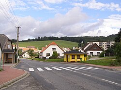
 Main street | |
| Coordinates: 49°21′41″N 15°29′27″E / 49.36139°N 15.49083°E | |
| Country | |
| Region | Vysočina |
| District | Jihlava |
| First mentioned | 1288 |
| Area | |
• Total | 8.90 km2 (3.44 sq mi) |
| Elevation | 519 m (1,703 ft) |
| Population (2024-01-01)[1] | |
• Total | 911 |
| • Density | 100/km2 (270/sq mi) |
| Time zone | UTC+1 (CET) |
| • Summer (DST) | UTC+2 (CEST) |
| Postal code | 588 61 |
| Website | www |
Kostelec (Czech pronunciation: [ˈkostɛlɛts]; German: Wolframs) is a municipality and village in Jihlava District in the Vysočina Region of the Czech Republic. It has about 900 inhabitants.
Geography
[edit]Kostelec is located about 7 kilometres (4 mi) southwest of Jihlava. It lies in the Křižanov Highlands. The highest point is the hill Kostelecký vrch at 657 m (2,156 ft) above sea level. The municipality is situated on the right bank od the Jihlava River, at its confluence with the stream Třešťský potok. The Třešťský potok supplies two fishponds in the southern part of the municipality.
History
[edit]The first written mention of Kostelec is from 1288.[2]
Demographics
[edit]
|
|
| ||||||||||||||||||||||||||||||||||||||||||||||||||||||
| Source: Censuses[3][4] | ||||||||||||||||||||||||||||||||||||||||||||||||||||||||
Economy
[edit]Since 1917, the meat packing factory Kostelecké uzeniny has been operating in the municipality.[5] It is the largest meat processor in the country.[6] With more than 1,000 employees, it is one of the largest employers in the region.[7]
Transport
[edit]Kostelec is located on the railway lines Jihlava–Tábor and Havlíčkův Brod–Slavonice. The municipality is served by two stations: Kostelec u Jihlavy, which is situated just outside the municipal territory, and Kostelec u Jihlavy masna; the latter one is situated just beside the meat packing factory.[8]
Sights
[edit]
The main landmark of Kostelec is the Church of Saint Cunigunde. It was built in 1250 on the site of an older wooden church. In the mid-15th century, it was extended. In the mid-17th century, it was rebuilt into its present form, but a Gothic side entrance portal from the original church has been preserved to this day.[9]
References
[edit]- ^ "Population of Municipalities – 1 January 2024". Czech Statistical Office. 2024-05-17.
- ^ "Počátky osídlování Českomoravské vysočiny" (in Czech). Obec Kostelec. Retrieved 2024-03-18.
- ^ "Historický lexikon obcí České republiky 1869–2011" (in Czech). Czech Statistical Office. 2015-12-21.
- ^ "Population Census 2021: Population by sex". Public Database. Czech Statistical Office. 2021-03-27.
- ^ "Historie a současnost" (in Czech). Kostelecké uzeniny, a.s. Retrieved 2024-03-28.
- ^ "Chcete (ne)mít Babiše na svátečním stole? Tady je přehled jeho značek v potravinářství" (in Czech). Asociace soukromého zemědělství ČR. 2020-12-22. Retrieved 2024-03-28.
- ^ "Registr ekonomických subjektů". Business Register (in Czech). Czech Statistical Office. Retrieved 2024-03-28.
- ^ "Detail stanice Kostelec u Jihlavy" (in Czech). České dráhy. Retrieved 2024-03-18.
- ^ "Kostel sv. Kunhuty se hřbitovem" (in Czech). National Heritage Institute. Retrieved 2024-03-18.


