Layo District
Appearance
Layo
Layu | |
|---|---|
![The train the Belmond Andean Explorer[1] at La Raya Station with market stalls and the mountain Chimpulla in the background, Layo District-Santa Rosa District](http://upload.wikimedia.org/wikipedia/commons/thumb/a/a9/Vista_Panor%C3%A1mica_del_distrito_de_Layo.jpg/250px-Vista_Panor%C3%A1mica_del_distrito_de_Layo.jpg) The train the Belmond Andean Explorer[1] at La Raya Station with market stalls and the mountain Chimpulla in the background, Layo District-Santa Rosa District | |
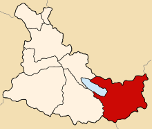
 Location of Layo in the Canas province | |
| Country | |
| Region | Cusco |
| Province | Canas |
| Founded | January 2, 1857 |
| Capital | Layo |
| Government | |
| • Mayor | Daniel Praxides Quispe Alanocca (2007) |
| Area | |
| • Total | 452.56 km2 (174.73 sq mi) |
| Elevation | 3,978 m (13,051 ft) |
| Population | |
| • Total | 6,822 |
| • Density | 15/km2 (39/sq mi) |
| Time zone | UTC-5 (PET) |
| UBIGEO | 080505 |
Layo District is one of eight districts in the Canas Province in Peru. The seat of the Layo District is the village Layo.
Geography
[edit]The La Raya mountain range traverses the district. Some of the highest mountains of the district are listed below:[2]
- Anta
- Anta Pata
- Aqu Muqu
- Chayña Tira
- Chawpi Tira
- Chimpulla
- Ch'ulluni
- Hatun Ichhuna Kunka
- Huch'uy K'uchu
- Jichu Qullu
- Kancha
- Kimsa Urqu
- Kiswarani
- Kunka
- Kuntur Sallana
- Laramani
- Pawka
- Pichaqani
- Pinqulluni
- Puka Puka
- Puka Urqu
- Pukara
- Phawsi Urqu
- Qayqu
- Q'atawi
- Sapan Warmi
- Saywani
- Suntur Qullu
- Sura Quta
- Tika Pallana
- Waylla Kunka
- Yana Ranra
Ethnic groups
[edit]The people in the district are mainly indigenous citizens of Quechua descent. Quechua is the language which the majority of the population (90.47%) learnt to speak in childhood, 9.39% of the residents started speaking using the Spanish language (2007 Peru Census).[3]
Sources
[edit]- ^ Belmont
- ^ escale.minedu.gob.pe - UGEL map of the Melgar Province (Puno Region)
- ^ inei.gob.pe Archived 2013-01-27 at the Wayback Machine INEI, Peru, Censos Nacionales 2007, Frequencias: Preguntas de Población
