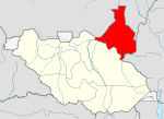
Manyo County
Appearance
Manyo | |
|---|---|
 | |
| Country | South Sudan |
| State | Upper Nile State |
| Area | |
• Total | 6,671 km2 (2,576 sq mi) |
| Population (2017 estimate[1]) | |
• Total | 54,034 |
| • Density | 8.1/km2 (21/sq mi) |
| Time zone | UTC+2 (CAT) |
Manyo is a county in Upper Nile State, South Sudan.[2]
References
[edit]- ^ "South Sudan: States and counties". www.citypopulation.de. Retrieved 2024-02-14.
- ^ "Referendum results: Upper Nile". Southern Sudan Referendum 2011. Archived from the original on 2012-03-08. Retrieved 2012-01-30.

