
Middlewood Way

The Middlewood Way is a 10-mile (16 km)[1] shared use path in north-west England, between Macclesfield and Rose Hill, Marple; it was opened on 30 May 1985 by Dr David Bellamy.[2] It serves the needs of walkers, dog walkers, cyclists, joggers and horse riders, playing host to a wide range of flora and fauna.
The management of the length of the Middlewood Way is shared between Cheshire East Council's Countryside Ranger Service and Stockport Metropolitan Borough Council.[1]
Railway history
[edit]The Middlewood Way follows the route of the former Macclesfield, Bollington and Marple railway, which had operated between 1869 and 1970. This section of railway connected Macclesfield and Rose Hill Marple, with trains continuing on to Manchester London Road.[3] The railway played a significant role in transporting goods, particularly cotton and coal, and provided passenger services connecting Macclesfield to Marple.
Initially, there were five stations on the line: Marple (Rose Hill), High Lane, Higher Poynton, Bollington and Macclesfield.[3] In 1879, a new station was opened at Middlewood; it was later renamed Middlewood Higher where the line crossed over Middlewood Lower station on the Buxton line.[4]
On 5 January 1970, the section between Rose Hill Marple and Macclesfield closed to all traffic, as part of the Beeching cuts which targeted underused railways across the UK and the track was lifted in early 1971. Only Rose Hill Marple station remained in operation, due to the high number of passengers commuting to Manchester Piccadilly; the station is now a single-tracked terminus for a spur off the Hope Valley Line.[3]
Recognising the potential for recreational use, Cheshire County Council converted the disused railway line into the Middlewood Way in 1985, creating a green corridor that preserved the area's natural and industrial heritage.[5]
Route
[edit]The path runs approximately parallel to the Macclesfield Canal and passes through Bollington and Higher Poynton. It can be reached by rail at Macclesfield, Middlewood, Rose Hill Marple and Romiley, via the Goyt Valley Connect 2 scheme.include:[6]
The trail forms part of National Cycle Network Route 55 from Ironbridge to Preston.[7]
Key access points and features along the route include:[6]
- Rose Hill Marple[nb 1]: The northern terminus, offering access to Marple and the Peak Forest Canal; there are regular train services to Manchester Piccadilly[8]
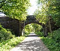
- High Lane: Features a disused railway station and a picnic site; the A6 crosses over the line
- Middlewood: Access to the Ladybrook Valley Interest Trail; Middlewood station, on the Buxton Line, provides services between Manchester Piccadilly, Stockport and Buxton.[8]
- Higher Poynton: Features a disused railway station, a picnic site, a cafe, a public house and access to the Macclesfield Canal; there is also a car park at Nelson's Pit
- Bollington: A historic mill town, home to the iconic White Nancy monument and several industrial heritage sites; the Macclesfield Canal passes by the old station site
- Macclesfield:[nb 2] The southern terminus, connecting to the wider network of trails and the Silk Road.
The route is mostly flat, making it suitable for users of varying abilities. It traverses woodlands, meadows, and farmland, providing a peaceful escape and opportunities to enjoy local wildlife.
Cultural and historical significance
[edit]In addition to its natural beauty, the Middlewood Way is a reminder of the region’s industrial past. Structures such as old railway bridges, station buildings and remnants of sidings can be seen along the route, adding a historical dimension to its appeal. The trail passes through Bollington, nicknamed Happy Valley, which is known for its rich textile heritage.[6]
Gallery
[edit]-
 The old station at Higher Poynton
 -
 The old station and tunnel under the A6 at High Lane
 -
 The Middlewood Way in summer
 -
 The Middlewood Way in winter


See also
[edit]Notes
[edit]References
[edit]- ^ a b "Middlewood Way". Cheshire East Council. Retrieved 19 April 2018.
- ^ Maconie, Stuart (2012). Never Mind the Quantocks. David & Charles. ISBN 978-1446301654. Retrieved 19 April 2018.
- ^ a b c Wright, Paul (22 May 2017). "Station name: Rose Hill Marple". Disused Stations. Retrieved 5 February 2025.
- ^ Catford, Nick; Wright, Paul (21 May 2017). "Station name: Middlewood Higher". Disused Stations. Retrieved 6 February 2025.
- ^ Emett, Charlie (1989). Walking Northern Railways: Volume 2 (West). Cicerone. ISBN 1-852840064.
- ^ a b c "Middlewood Way". Peaks and Puddles. Retrieved 5 February 2025.
- ^ "Route 55". Sustrans. Retrieved 19 April 2018.
- ^ a b "Timetables and engineering information for travel with Northern". Northern Railway. 15 December 2024. Retrieved 4 February 2025.
External links
[edit]- Discover Cheshire: with detailed map
- Peaks & Puddles: detailed guide, with photos of current route
- Visit Cheshire: with directions