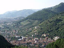
Montignoso
Appearance
You can help expand this article with text translated from the corresponding article in Italian. (June 2019) Click [show] for important translation instructions.
|
Montignoso | |
|---|---|
| Comune di Montignoso | |
 | |
| Coordinates: 44°1′N 10°10′E / 44.017°N 10.167°E | |
| Country | Italy |
| Region | Tuscany |
| Province | Massa and Carrara (MS) |
| Frazioni | Capanne, Cerreto, Cervaiolo, Cinquale, Corsanico, Debbia, Palatina, Pasquilio, Piazza, Porta (lago), Prato, Renella, Rifugio Pasquilio, Sant'Eustachio, San Vito, Serra, Vietina |
| Government | |
| • Mayor | Gianni Lorenzetti |
| Area | |
| • Total | 16.74 km2 (6.46 sq mi) |
| Elevation | 131 m (430 ft) |
| Population | |
| • Total | 10,289 |
| • Density | 610/km2 (1,600/sq mi) |
| Demonym(s) | Montignosini, Monceri |
| Time zone | UTC+1 (CET) |
| • Summer (DST) | UTC+2 (CEST) |
| Postal code | 54038 |
| Dialing code | 0585 |
| Website | Official website |
Montignoso is a comune (municipality) in the Province of Massa and Carrara in the Italian region Tuscany, located about 90 kilometres (56 mi) northwest of Florence and about 3 kilometres (1.9 mi) southeast of Massa.

Montignoso borders the following municipalities: Forte dei Marmi, Massa, Pietrasanta, Seravezza.
References
[edit]- ^ "Superficie di Comuni Province e Regioni italiane al 9 ottobre 2011". Italian National Institute of Statistics. Retrieved 16 March 2019.
- ^ All demographics and other statistics: Italian statistical institute Istat.
- ^ "Popolazione Residente al 1° Gennaio 2018". Italian National Institute of Statistics. Retrieved 16 March 2019.
External links
[edit]![]() Media related to Montignoso at Wikimedia Commons
Media related to Montignoso at Wikimedia Commons


