
Portal:Scottish islands
The Scottish Islands Portal
Welcome! — Fàilte! — Walcome!
-

 Looking from the Isle of Mull towards Ardnamurchan peninsula as the Caledonian MacBrayne ferry MV Clansman sails past the Rubha nan Gall lighthouse
 -
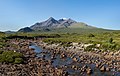
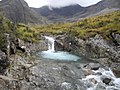
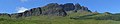
 The Cuillin, Isle of Skye
 -
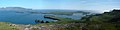
 View from Elgol on the Isle of Skye across to the Cuillin
 -
-
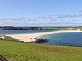
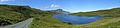
 Seilebost on Harris
 -
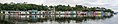
 Portree Waterfront, Isle of Skye
 -

-

-
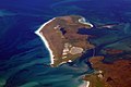
 Tombolo connecting St Ninian's Isle to Mainland, Shetland


Scotland has around 900 offshore islands, most of which are to be found in four main groups: Shetland, Orkney, and the Hebrides, sub-divided into the Inner Hebrides and Outer Hebrides. There are also clusters of islands in the Firth of Clyde, Firth of Forth, and Solway Firth, and numerous small islands within the many bodies of fresh water in Scotland including Loch Lomond and Loch Maree. The largest island is Lewis and Harris, which extends to 2,179 km2 (841 sq mi), and there are a further 200 islands which are greater than 40 hectares (100 acres) in area. Of the remainder, several, such as Staffa and the Flannan Isles, are well-known, despite their small size. Some 94 Scottish islands are permanently inhabited, of which 89 are offshore islands. Between 2001 and 2011, Scottish island populations as a whole grew by 4% to 103,702.
The geology and geomorphology of the islands is varied. Some, such as Skye and Mull, are mountainous, while others like Tiree and Sanday are relatively low-lying. Many have bedrock made from ancient Archaean Lewisian Gneiss which was formed 3 billion years ago; Shapinsay and other Orkney islands are formed from Old Red Sandstone, which is 400 million years old; and others such as Rùm from more recent Tertiary volcanoes. Many of the islands are swept by strong tides, and the Corryvreckan tide race between Scarba and Jura is one of the largest whirlpools in the world. Other strong tides are to be found in the Pentland Firth between mainland Scotland and Orkney, and another example is the "Grey Dog" between Scarba and Lunga. (More on Scottish islands...)
Selected picture
-
 Blackhouses were the traditional form of house across the Hebrides and the Highlands; this example is at Arnol, Lewis
Credit: LornaMCampbell
-
-
 The Neolithic farmstead of Knap of Howar on Papa Westray, Orkney, dates from 3700 BC and might be the oldest surviving stone dwelling in northern Europe
Credit: Me677
-
 The cliffs of Eshaness, North Mainland, Shetland
Credit: ThoWi
-
 The 1st-century Dun Carloway on Lewis is a well-preserved example of an Iron Age broch, a type of complex Atlantic roundhouse only found in Scotland
Credit: Morris R. Maciver
-
 White-tailed eagle fishing off Mull, one of several islands to which the birds have been successfully re-introduced
Credit: Jacob Spinks
-
 The Corryvreckan Whirlpool in the narrow Gulf of Corryvreckan between Jura and Scarba
Credit: Walter Baxter
-
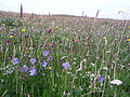 Wildflowers in machair, a coastal dune grassland found in the Outer Hebrides and elsewhere
Credit: Jon Thomson
-
 Baile Mòr, the village on Iona
Credit: Clydecoast
-
 Alasdair Crotach MacLeod is the first McLeod not to be buried on Iona; his tomb on Harris dates from 1528, and is among the finest of this period in Scotland
Credit: Gvdwiele
-
-
 Neist Point Lighthouse on Skye was designed by David Alan Stevenson and dates from 1909
Credit: Lionel Ulmer
-
 Aerial view of the ruins of a hermitage on Canna
Credit: Peter Van den Bossche
-
-
 Rubha nan Gall lighthouse, Tobermory, Mull, built in 1857 by David and Thomas Stevenson, with a Caledonian MacBrayne ferry in the background
Credit: Colin
-

-
-
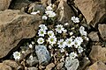 Shetland mouse-ear, a rare plant species unique to Shetland and found only on two serpentine hills in the Keen of Hamar reserve on the island of Unst
Credit: Melvin Grey
-
 Barra Airport is the only one in the world to use a beach as a regular runway
Credit: Steve Houldsworth
-
 The Bruichladdich distillery, one of eight on Islay; single-malt whisky is a major product of the islands
Credit: Bdcl1881
-

-
-

-
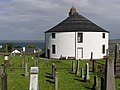 Kilarrow Parish Church, known as the Round Church, is a Georgian building in Bowmore on Islay
Credit: Ronsteenvoorden
-
-

-

-
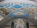 The Italian Chapel on Lamb Holm, Orkney was built from two Nissen huts by Italian prisoners of war during World War 2; the interior frescoes are by Domenico Chiocchetti
Credit: Renata
-
 The tied island of St Ninian's Isle is joined to the Shetland Mainland by the largest tombolo in the UK
Credit: ThoWi
-

-

-
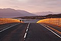 Skye Bridge, opened in 1995; the toll was lifted in 2004
Credit: Gene Selkov
-
 Eilean Donan Castle at the confluence of three sea lochs, Loch Duich, Loch Long and Loch Alsh
Credit: Diliff
-
 Duart Castle, a 13th-century castle on Mull, the historical seat of Clan Maclean
Credit: Philippe Giabbanelli
-
-
-
 The ferry from Glenelg to Kylerhea on Skye has run for 400 years; the present boat, MV Glenachulish, is the only hand-operated turntable ferry still in operation
Credit: Wojsyl

_2.jpg)


.jpg)


.jpg)


.jpg)

.jpg)


.jpg)


Selected island group

The Northern Isles (Scots: Northern Isles; Old Norse: Norðreyjar; Norn: Nordøjar) are a chain (or archipelago) of islands of Scotland, located off the north coast of the Scottish mainland. The climate is cool and temperate and highly influenced by the surrounding seas. There are two main island groups: Shetland and Orkney. There are a total of 36 inhabited islands, with the fertile agricultural islands of Orkney contrasting with the more rugged Shetland islands to the north, where the economy is more dependent on fishing and the oil wealth of the surrounding seas. Both archipelagos have a developing renewable energy industry. They share a common Pictish and Norse history, and were part of the Kingdom of Norway before being absorbed into the Kingdom of Scotland in the 15th century. The islands played a significant naval role during the world wars of the 20th century.
Tourism is important to both archipelagos, with their distinctive prehistoric ruins playing a key part in their attraction, and there are regular ferry and air connections with mainland Scotland. The Scandinavian influence remains strong, especially in local folklore and both island chains have strong, though distinct local cultures. The names of the islands are dominated by the Norse heritage, although some may retain pre-Celtic elements. (Full article...)
News

- 12 February: The BiFab construction yard at Arnish near Stornoway, Isle of Lewis, is purchased by InfraStrata.
- 11 February: Wild fires occur in Benbecula; and at Achmore and Sildinish in the Isle of Lewis; Horsaclete in Harris; Brevig in Barra; and Eubhal in North Uist.
- 19 January: Barra and Vatersay are put under tier-4 restrictions after an outbreak of Covid-19.
- 18 January: The Shetland Space Centre submits plans for a spaceport on Unst (proposed site pictured), Shetland, including three rocket launch pads.
- 8 January: Distilleries in Orkney and South Uist receive government grants to research ways of reducing their CO2 emissions.
- 4 January: After the UK leaves the European Union, the Northern Celt, an Irish fishing boat based out of Greencastle, County Donegal, is ordered to leave the 12-nautical-mile zone around Rockall by officers of Marine Scotland.
- 1 January: A total of 72 cases of Covid-19 are recorded in an ongoing outbreak in Shetland.
- 9 December: A review by a committee of MSPs into the commissioning and building of two new dual-fuel Caledonian MacBrayne ferries, MV Glen Sannox and "hull 802", criticises CMAL, Transport Scotland and the Scottish government, as well as the ship builders, Ferguson Marine.
- 3 December: North-east Lewis, Sea of the Hebrides and Shiant East Bank are designated Marine Protected Areas, while East Mainland Coast Shetland, Sound of Gigha, Coll and Tiree, Rùm, the west coast of the Outer Hebrides, and the waters off St Kilda and Foula are designated Special Protection Areas.
- 30 November: Michael Russell, MSP for Argyll and Bute, and David Stewart and John Finnie, MSPs for the Highlands and Islands region, will stand down at the 2021 election.
- 17 November: Phytophthora ramorum-infected larch trees in Arran are to be felled over a 543-acre area, to prevent the fungus-like pathogen from spreading.
- 4 November: The Scottish Wildlife Trust objects to a proposed salmon farm in the Marine Protected Area of Wester Ross, near Horse Island, Summer Isles, because of the potential impact on kelp forests and maerl beds.
Selected fauna

The northern gannet (Morus bassanus) is a seabird, the largest species of the gannet family, Sulidae. It is native to the coasts of the Atlantic Ocean, breeding in Western Europe and Northeastern North America. It is the largest seabird in the northern Atlantic. The sexes are similar in appearance. The adult northern gannet has a mainly white streamlined body with a long neck, and long and slender wings. It is 87–100 cm (34+1⁄2–39+1⁄2 in) long with a 170–180 cm (67–71 in) wingspan. The head and nape have a buff tinge that is more prominent in breeding season, and the wings are edged with dark brown-black feathers. The long, pointed bill is blue-grey, contrasting with black, bare skin around the mouth and eyes. Juveniles are mostly grey-brown, becoming increasingly white in the five years it takes them to reach maturity.
Nesting takes place in colonies on both sides of the North Atlantic, the largest of which are at Bass Rock (75,000 pairs as of 2014), St. Kilda (60,000 pairs as of 2013) and Ailsa Craig (33,000 pairs as of 2014) in Scotland, Grassholm in Wales, and Bonaventure Island (60,000 pairs in 2009) off the coast of Quebec. Its breeding range has extended northward and eastward, with colonies being established on Russia's Kola Peninsula in 1995 and Bear Island (the southernmost island of Svalbard), in 2011. Colonies are mostly located on offshore islands with cliffs, from which the birds can more easily launch into the air. The northern gannet undertakes seasonal migrations and catches fish (which are the mainstay of its diet) by making high-speed dives into the sea.
The northern gannet was previously hunted for food in certain parts of its range, and although that practice still continues in the Outer Hebrides of Scotland and the Faroe Islands, the bird faces few other natural or man-made threats. Since its population is growing, the International Union for Conservation of Nature considers it a least-concern species. Because it is both a conspicuous and a common bird, it is referred to in several ancient myths and legends. (Full article...)
Selected history & culture article

The stoor worm, or Mester Stoor Worm, was a gigantic evil sea serpent of Orcadian folklore, capable of contaminating plants and destroying animals and humans with its putrid breath. It is probably an Orkney variant of the Norse Jörmungandr, also known as the Midgard Serpent, or world serpent, and has been described as a sea dragon.
The king of one country threatened by the beast's arrival was advised to offer it a weekly sacrifice of seven virgins. In desperation, the king eventually issued a proclamation offering his kingdom, his daughter's hand in marriage, and a magic sword to anyone who could destroy the monster. Assipattle, the youngest son of a local farmer, defeated the creature; as it died its teeth fell out to become the islands of Orkney, Shetland and the Faroes, and its body became Iceland.
Similarities between Assipatle's defeat of the monster and other dragon-slayer tales, including Herakles' destruction of a sea monster to save Hesione, have been noted by several authors. It has been suggested that tales of this genre evolved during a period of enlightenment when human sacrifices to bestial divinities were beginning to be suppressed. (Full article...)
Selected island

Staffa (Scottish Gaelic: Stafa, pronounced [ˈs̪t̪afa], from the Old Norse for stave or pillar island) is an island of the Inner Hebrides in Argyll and Bute, Scotland. The Vikings gave it this name as its columnar basalt reminded them of their houses, which were built from vertically placed tree-logs.
Staffa lies about 10 kilometres (6 miles) west of the Isle of Mull; its area is 33 hectares (82 acres) and the highest point is 42 metres (138 feet) above sea level.
The island came to prominence in the late 18th century after a visit by Sir Joseph Banks. He and his fellow-travellers extolled the natural beauty of the basalt columns in general and of the island's main sea cavern, which Banks renamed 'Fingal's Cave'. Their visit was followed by those of many other prominent personalities throughout the next two centuries, including Queen Victoria and Felix Mendelssohn. The latter's Hebrides Overture brought further fame to the island, which was by then uninhabited. It is now in the care of the National Trust for Scotland. (Full article...)
Did you know?

- ... that the Lewisian gneiss (pictured) forms the basement to Torridonian and Cambro-Ordovician sedimentary rocks in the Hebridean Terrane?
- ... that the German battleship SMS Kaiser damaged the British battleship HMS Warspite during the Battle of Jutland in 1916 which forced it to withdraw from the battle?
- ... that Amie MacRuari was divorced by the first Lord of the Isles despite giving him no grounds for doing so?
- ... that according to local tradition, the rental paid to the king for the Scottish castle and island of Fraoch Eilean was one snowball?
Selected portrait
-
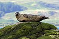
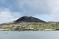
 Seals hauled out by Lyrie Geo on Hoy
Credit: Claire Pegrum
-
 The Standing Stones of Stenness, near Stromness, Orkney, started by 3100 BC and possibly Britain's oldest henge site
Credit: Fantoman400
-
 Puffins and guillemots on Lunga in the Treshnish Isles, with Bac Mòr (known as Dutchman's Cap for its distinctive shape) in the background
Credit: Simaron
-

-

-
-
 Columba was a 6th-century Irish-born saint who spread Christianity in Scotland and founded Iona Abbey, where he is commemorated in this stained-glass window
Credit: Vegansoldier
-

-
 Scottish Gaelic speakers in the 2011 census; the Outer Hebrides, Tiree, Raasay, Skye and Lismore have the highest proportion of speakers
Credit: SkateTier
-
 The 8th-century Kildalton Cross, Islay, one of the best-preserved Celtic crosses in Scotland
Credit: Tom Richardson
-

-
 The North Carr Beacon at low tide; the unlit beacon was built between 1813 and 1821 by Robert Stevenson to warn shipping of the North Carr Reef near Fife Ness
Credit: Kathrinpassig
-


Selected geography article

Sabhal Mòr Ostaig ([ˌs̪ɔɫ̪ ˌmoɾ ˈɔs̪t̪ɪkʲ]; lit. 'Great Barn of Ostaig') is a public higher education college situated in the Sleat peninsula in the south of the Isle of Skye, Scotland with an associate campus at Bowmore on the island of Islay. Sabhal Mòr is an independent Academic Partner in the federal University of the Highlands and Islands. Its sole medium of instruction on degree courses is Scottish Gaelic.
Since its foundation in 1973 Sabhal Mòr Ostaig has played a crucial role in the linguistic and cultural renaissance of Gaelic in Scotland. The college enjoys an international reputation for the study of the history and literature of the Gàidhealtachd, past and present; for research into political, educational, and community aspects of minority language maintenance and revitalisation; and for its engagement with Gaelic creative arts, as well as with broadcast and online media.
Sabhal Mòr's research base has been further strengthened to take in sociolinguistics, through the Soillse initiative; corpus planning and historical lexicography, through the Stòrdata Nàiseanta na Gàidhlig/Gaelic Terminology Database and the Faclair na Gàidhlig/Dictionary of Scottish Gaelic projects; and toponomy, through the Ainmean-Àite na h-Alba/Gaelic Place-Names of Scotland advisory partnership, all based at the college. Research capacity is underpinned by the Sabhal Mòr Ostaig Library with its internationally important collections of material related to Gaelic and to the Highlands, and further complemented by the proximity of two major Highland archives: those of MacDonald of Sleat in the Museum of the Isles by Armadale Castle, and the MacLeod papers in Dunvegan Castle. Through academic collaboration and student exchanges, the college maintains links with partner institutions in Scotland, Ireland, Wales, and Nova Scotia.
With residencies for writers, artists, musicians, and dramatists; its degree courses in media and traditional music; its hosting of the national folklore digitisation project Tobar an Dualchais/Kist o Riches; and Fàs, its £8-million centre for creative industries, Sabhal Mòr fulfils an important cultural remit both in the Highlands and in Scotland more generally. (Full article...)
Selected biography
.jpg)
Jack Wilson McConnell, Baron McConnell of Glenscorrodale, PC (born 30 June 1960) is a Scottish politician who served as first minister of Scotland and leader of the Labour Party in Scotland from 2001 to 2007. McConnell served as the Minister for Finance from 1999 to 2000 and Minister for Education, Europe and External Affairs from 2000 to 2001. He has been a Labour life peer in the House of Lords since 2010 and previously served as a Member of the Scottish Parliament (MSP) for Motherwell and Wishaw from 1999 to 2011. McConnell held the Presidency of the Conference of European Regions with Legislative Power (REGLEG) during November 2003 to November 2004.
Born in Irvine, Ayrshire, McConnell studied at the University of Stirling and worked as a mathematics teacher at Lornshill Academy. His political career began when he was elected to Stirling District Council, while he was still teaching. He served as a member of the Scottish Constitutional Convention, having campaigned in favour of a Scottish Parliament in the 1997 devolution referendum. Elected to serve as an MSP for the Motherwell and Wishaw constituency in the 1999 Scottish Parliament election, McConnell was appointed Minister for Finance under the Donald Dewar government. After Dewar's death in 2000, he ran unsuccessfully for the leadership of the Labour Party in Scotland, having been defeated by Henry McLeish. McLeish appointed McConnell as Minister for Education, Europe and External Affairs.
In 2001, McLeish resigned in the aftermath of the Officegate scandal and McConnell was elected unopposed as the Scottish Labour leader. He was appointed First Minister on 22 November 2001, becoming the youngest office holder. As first minister, he implemented a ban on smoking in public places, signed a Co-operation Agreement with Malawi, and successfully bid for the 2014 Commonwealth Games to be hosted in Glasgow. In the 2007 Scottish Parliament election, the Labour Party in Scotland became the second largest party, with the SNP having one seat more. This therefore lead to McConnell losing office, becoming the first (and as of 2025, only) First Minister to have been defeated in office, and as of 2025, the last Labour First Minister of Scotland in office.
After losing office as first minister, McConnell sat as the Leader of the Opposition in Holyrood, until his resignation as leader. He sat as a backbencher and stood down as an MSP in the 2011 election. In 2010, McConnell became a member of the House of Lords of the United Kingdom. He made a commitment to continuing his work to tackle poverty in Africa and to develop the relationship between Scotland and Malawi. (Full article...)
Related portals
Selected panorama
-
-
-

-
-

-
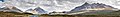
 Small freshwater islets on Loch Assynt
Credit: Vincent
-

-
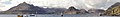
 Eilean Donan
Credit: Stefan Krause
-
-
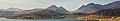
 Iona Abbey
Credit: Oliver-Bonjoch
-

-


Topics
|  | ||||||||||||||||
|
| |||||||||||||||||
| |||||||||||||||||
| |||||||||||||||||
| |||||||||||||||||
| |||||||||||||||||
| |||||||||||||||||
| |||||||||||||||||
Categories
The main category is Islands of Scotland, with subcategories

Things you can do
- Add new articles to the project by placing {{WPSI|class=|importance=}} on the talk page
- Add a link to the portal in the "See also" section of relevant articles with {{Portal|Scottish islands}}
- Take requested photographs or create requested pages, including Prehistoric Hebrides, Trialabreac, Dog Isle...
- Expand a Scottish Islands stub into a full article, adding images, citations, references and infoboxes; did you know that if you expand one 5x, you can nominate it for Did You Know?
- Improve one of the highest priority articles, including Mull, Bute, North & South Uist, Columba, Highland Clearances, Sorley MacLean, St Magnus Cathedral...
- Follow these hints to improve a B-class article and nominate it for Good Article

- Suggest articles, pictures, interesting facts, events and news to be featured here on the portal
Wikiproject

Associated Wikimedia
The following Wikimedia Foundation sister projects provide more on this subject:
-
 Commons
Free media repository -
 Wikibooks
Free textbooks and manuals -
 Wikidata
Free knowledge base -
 Wikinews
Free-content news -
 Wikiquote
Collection of quotations -
 Wikisource
Free-content library -
 Wikiversity
Free learning tools -
 Wikivoyage
Free travel guide -
 Wiktionary
Dictionary and thesaurus


