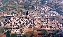
Picanya
Appearance
Picanya | |
|---|---|
 | |
| Coordinates: 39°26′10″N 0°26′6″W / 39.43611°N 0.43500°W | |
| Country | |
| Autonomous community | |
| Province | Valencia |
| Comarca | Horta Oest |
| Judicial district | Torrente |
| Government | |
| • Alcalde | Josep Almenar i Navarro |
| Area | |
| • Total | 7.1 km2 (2.7 sq mi) |
| Elevation | 15 m (49 ft) |
| Population (2018)[1] | |
| • Total | 11,409 |
| • Density | 1,600/km2 (4,200/sq mi) |
| Demonym | Picañero/a |
| Time zone | UTC+1 (CET) |
| • Summer (DST) | UTC+2 (CEST) |
| Postal code | 46210 |
| Official language(s) | Valencian |
| Website | Official website |
Picanya (Valencian pronunciation: [piˈkaɲa]) is a municipality in the comarca of Horta Sud in the Valencian Community, Spain.[2]
Summary of council election results
[edit]The Spanish Socialist Workers' Party has had an absolute majority of seats since the restoration of democracy in the late 1970s.
| 1979 | 1983 | 1987 | 1991 | 1995 | 1999 | 2003 | 2007 | 2011 | 2015 | 2019 | 2023 | |
|---|---|---|---|---|---|---|---|---|---|---|---|---|
| Spanish Socialist Workers' Party (PSOE) | 12 | 9 | 9 | 10 | 8 | 9 | 9 | 9 | 9 | 9 | 11 | 9 |
| United Left (IU) | 1 | 1 | 1 | |||||||||
| People's Party (PP) | 4 | 4 | 3 | 4 | 4 | 4 | 7 | 7 | 3 | 2 | 4 | |
| Valencian Union (UV) | ||||||||||||
| Coalició Compromís (Compromís) | 1 | 3 | 2 | 3 | ||||||||
| Citizens (Cs) | 2 | 2 | ||||||||||
| Vox (Vox) | 1 | |||||||||||
| Total number of seats | 13 | 13 | 13 | 13 | 13 | 13 | 13 | 17 | 17 | 17 | 17 | 17 |
Source:[3]
References
[edit]- ^ Municipal Register of Spain 2018. National Statistics Institute.
- ^ Navalón, Teresa (15 July 2021). "L'Horta Oest tiene los días contados: auge y caída de una "subcomarca" fantasma" [L'Horta Oest's days are numbered: rise and fall of a phantom sub-comarca]. Valenciaplaza.com (in Spanish). Valencia, Spain. Retrieved 24 July 2021.
- ^ Mislata local results, argos.gva.es accessed 24 July 2021


