Portal:San Francisco Bay Area
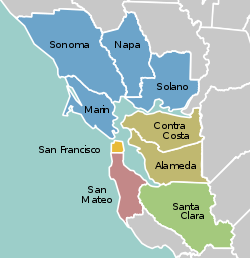
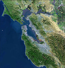
The San Francisco Bay Area Portal  The San Francisco Bay Area (referred to locally as the Bay Area) is a populous region surrounding the San Francisco and San Pablo estuaries in Northern California. The region encompasses the major cities and metropolitan areas of San Jose, San Francisco, and Oakland, along with smaller urban and rural areas. The Bay Area's nine counties are Alameda, Contra Costa, Marin, Napa, San Francisco, San Mateo, Santa Clara, Solano, and Sonoma. Home to approximately 7.68 million people, the nine-county Bay Area contains many cities, towns, airports, and associated regional, state, and national parks, connected by a network of roads, highways, railroads, bridges, tunnels, and commuter rail. The combined statistical area of the region is the second-largest in California (after the Greater Los Angeles area), the fifth-largest in the United States, and the 43rd-largest urban area in the world with 8.80 million people. The Bay Area has the second-most Fortune 500 companies in the United States, after the New York metropolitan area, and is known for its natural beauty, liberal politics, entrepreneurship, and diversity. The area ranks second in highest density of college graduates, after the Washington, D.C. metropolitan area and performs above the state median household income in the 2010 census; it includes the five highest California counties by per capita income and two of the top 25 wealthiest counties in the United States. Based on a 2013 population report from the California Department of Finance, the Bay Area is the only region in California where the rate of people migrating in from other areas in the United States is greater than the rate of those leaving the region, led by Alameda and Contra Costa counties. (more...) Selected article The California Gold Rush (1848–1855) began on January 24, 1848, when gold was found by James W. Marshall at Sutter's Mill in Coloma, California. The first to hear confirmed information about gold in California were residents of Oregon, the Sandwich Islands (Hawaii), western Mexico, and Central America. They were the first to go there in late 1848. All told, the news of gold brought some 300,000 people to California from the rest of the United States and abroad. Of the 300,000, approximately half arrived by sea and half came overland from the east, on the California Trail and the Gila River trail. The effects of the Gold Rush were substantial. San Francisco grew from a small settlement of about 200 residents in 1846 to a boomtown of about 36,000 by 1852. Roads and other towns were built throughout California. In 1849 a state constitution was written, and a governor and legislature were chosen. California became a state as part of the Compromise of 1850. more... Selected biography Selected city Selected image
The Bay Area by year1961

Selected historical imageDid you know...
Previous Did you know... 
Selected periodic event The Luther Burbank Rose Parade and Festival is an annual festival held in Santa Rosa celebrating the work of Luther Burbank, and centered on the Luther Burbank Home and Gardens (pictured). It began in 1894, and today has a budget of $100,000, with up to 250,000 attending. Quote
~ Otis Redding, The Dock of the Bay (1967)
Selected multimedia file1898 launch of the Imperial Japanese Navy cruiser Chitose , filmed by Thomas Edison Co. credit: Library of Congress
Bay Area regions, geographic features and protected areasRelated PortalsWikiProject
Things you can do *Write an article on a Bay Area-related subject Selected panoramaSan Francisco Bay Area categoriesBay Area | San Francisco Bay | San Francisco | San Jose | Oakland | Cities | Census-designated places | Historic Places | National Landmarks | Counties: Alameda | Contra Costa | Marin | Napa | San Mateo | Santa Clara | Solano | Sonoma
Architecture | Attractions | Books | Culture | Economy | Education | Environment | Events & Festivals | Geography | Government | History | Landmarks | Law | Mass media | Military | Music | Organizations | Parks | People | Politics | Science | Sports | Transport
Full category tree
Select [►] to view the full category tree.
Associated WikimediaThe following Wikimedia Foundation sister projects provide more on this subject:
Discover Wikipedia using portals |
- All portals
- San Francisco Bay Area portal
- San Francisco Bay Area portal selected article pages
- San Francisco Bay Area portal selected biography pages
- San Francisco Bay Area portal selected city pages
- San Francisco Bay Area portal selected picture pages
- San Francisco Bay Area portal years pages
- San Francisco Bay Area portal selected historical image pages
- San Francisco Bay Area portal did you know pages
- San Francisco Bay Area portal festivals pages
- San Francisco Bay Area portal quotes pages
- San Francisco Bay Area portal selected multimedia pages
- San Francisco Bay Area portal selected panorama pages
- California portals
- San Francisco Bay Area
- United States portals by city


