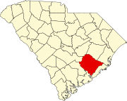
Pringletown, South Carolina
Appearance
Pringletown, South Carolina | |
|---|---|
| Coordinates: 33°08′38″N 80°18′21″W / 33.14389°N 80.30583°W | |
| Country | United States |
| State | South Carolina |
| County | Berkeley |
| Named for | Pringle family |
| Elevation | 56 ft (17 m) |
| Time zone | UTC-5 (Eastern (EST)) |
| • Summer (DST) | UTC-4 (EDT) |
| ZIP code | 29472[1] |
| Area code | 843 and 854 |
| GNIS feature ID | 1250248[2] |
Pringletown is an unincorporated community in Berkeley County, South Carolina, United States. It is located along Old Gilliard Road (SC 27), north of Interstate 26 (exit 187). Formally spelled "Pringle Town," the community was named after the Pringle family, which lived in the area.[3]
The community is the closest populated place to both the MacDougall Correctional Institution, located north along Old Gilliard Road, and the Volvo Cars - South Carolina Factory, located east via Autonomous Drive.
References
[edit]- ^ "USPS Carrier Route Maps". Melissa Lookups. Archived from the original on April 18, 2021. Retrieved April 18, 2021.
- ^ "Pringletown, South Carolina". Geographic Names Information System. United States Geological Survey, United States Department of the Interior. Retrieved April 18, 2021.
- ^ Neuffer, Claude Henry; Neuffer, Irene (1967). Claude and Irene Neuffer's Names in South Carolina Vols. XIII-XVIII, 1966-1971. South Carolina: The Reprint Company. p. 31. ISBN 9780871523914. Retrieved April 18, 2021.


