Quistinic
Quistinic
Kistinid | |
|---|---|
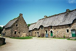
 The village of Poul-Fetan | |
| Coordinates: 47°54′21″N 3°07′59″W / 47.9058°N 3.1331°W | |
| Country | France |
| Region | Brittany |
| Department | Morbihan |
| Arrondissement | Lorient |
| Canton | Guidel |
| Intercommunality | Lorient Agglomération |
| Government | |
| • Mayor (2020–2026) | Antoine Pichon[1] |
Area 1 | 42.95 km2 (16.58 sq mi) |
| Population (2022)[2] | 1,423 |
| • Density | 33/km2 (86/sq mi) |
| Time zone | UTC+01:00 (CET) |
| • Summer (DST) | UTC+02:00 (CEST) |
| INSEE/Postal code | 56188 /56310 |
| Elevation | 20–177 m (66–581 ft) |
| 1 French Land Register data, which excludes lakes, ponds, glaciers > 1 km2 (0.386 sq mi or 247 acres) and river estuaries. | |
Quistinic (French pronunciation: [kistinik]; Breton: Kistinid) is a commune in the Morbihan department of Brittany in north-western France.[3] Its sister city is the rural village of Loughshinny, which is in County Dublin, Ireland.[4]
Population
[edit]The inhabitants of Quistinic are called Quistinicois in French.
|
| ||||||||||||||||||||||||||||||||||||||||||||||||||||||||||||||||||||||||||||||||||||||||||||||||||||||||||||||||||
| |||||||||||||||||||||||||||||||||||||||||||||||||||||||||||||||||||||||||||||||||||||||||||||||||||||||||||||||||||
| Source: EHESS[5] and INSEE (1968-2020)[6] | |||||||||||||||||||||||||||||||||||||||||||||||||||||||||||||||||||||||||||||||||||||||||||||||||||||||||||||||||||
Toponymy
[edit]Quistinic is a word in the Breton language. It means "Chesnust Forest".
Geography
[edit]
The village centre is located 25 km (16 mi) northeast of Lorient, 39 km (24 mi) northwest of Vannes and 110 km (68 mi) west of Rennes. Historically, Quistinic belongs to the Vannetais. The river Blavet forms the commune's eastern and southern borders. The neighborhood of the hamlet of Poul Fetan, in Quistinic, offers a nice view over the Blavet valley. Quistinic is characterised by a bocage landscape.
Neighboring communes
[edit]Quistinic is border by Bubry and Melrand to the north, by Saint-Barthélemy and Baud to the east, by Languidic to the south and by Lanvaudan to the west.
Map
[edit]Village of Poul-Fétan
[edit]
Poul-Fétan which etymologically means "Lavoir (wash-house) of the fountain" (French: Lavoir de la fontaine) is an historical center that is located within Quistinic. This hamlet, originating in the sixteenth century, has been completely restored with traditional materials. The houses are covered with thatching, and the old lavoir and the ancient hemp rusting containers are present. Visitors can notably enter the Longère located in a farmhouse and witness an interior of the early twentieth century reconstituted and observe the craftsmen at work showing their expertise.[7]
Gallery
[edit]-
Chapel of Locmaria
-
Villeneuve-Jacquelot castle
-
Old house in the village centre
-
Monument erected in memory of the victims of the twentieth century wars.
See also
[edit]References
[edit]- ^ "Maires du Morbihan" (PDF). Préfecture du Morbihan. 7 July 2020.
- ^ "Populations de référence 2022" (in French). The National Institute of Statistics and Economic Studies. 19 December 2024.
- ^ INSEE commune file
- ^ Jumelage Quistinic-Loughshinny-Sumène
- ^ Des villages de Cassini aux communes d'aujourd'hui: Commune data sheet Quistinic, EHESS (in French).
- ^ Population en historique depuis 1968, INSEE
- ^ Dubost, Jean-Michel (1980). "Restauration du village de Poul-Fetan en Quistinic [Morbihan]". Tiez Breiz, Maisons Paysannes de Bretagne. No. 1. pp. 24–25.
External links
[edit]- Cultural Heritage (in French)
- Mayors of Morbihan Association (in French)


