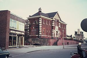
Rochester Bridge railway station
Appearance
Rochester Bridge | |
|---|---|
 | |
| General information | |
| Location | Rochester, Borough of Medway England |
| Grid reference | TQ739690 |
| Platforms | 2 |
| Other information | |
| Status | Disused |
| History | |
| Original company | London, Chatham and Dover Railway[1] |
| Pre-grouping | South Eastern and Chatham Railway |
| Key dates | |
| 3 Dec 1860 | Opened as Strood[1] |
| 1 Apr 1861 | Renamed Rochester Bridge |
| 1 Nov 1861 | Renamed Rochester and Strood |
| Mar 1892 | Renamed Rochester Bridge (Strood) |
| Jan 1905 | Renamed Rochester Bridge |
| 1 Jan 1917 | Closed |
Rochester Bridge railway station served Rochester and Strood in Kent, England.
It was opened as Strood by the London, Chatham and Dover Railway in 1860. After several name changes and the merger of the LC&DR into the South Eastern and Chatham Railway, it closed as Rochester Bridge in 1917. It lay derelict until it was demolished in the late 1960s in preparation for widening of the A2 road, which opened in 1970, its bridge of the River Medway using the piers of the southern span of the railway bridge.
Medway Towns | ||||||||||||||||||||||||||||||||||||||||||||||||||||||||||||||||||||||||||||||||||||||||||||||||||||||||||||||||||||||||||||||||||||||||||||||||||||||||||
|---|---|---|---|---|---|---|---|---|---|---|---|---|---|---|---|---|---|---|---|---|---|---|---|---|---|---|---|---|---|---|---|---|---|---|---|---|---|---|---|---|---|---|---|---|---|---|---|---|---|---|---|---|---|---|---|---|---|---|---|---|---|---|---|---|---|---|---|---|---|---|---|---|---|---|---|---|---|---|---|---|---|---|---|---|---|---|---|---|---|---|---|---|---|---|---|---|---|---|---|---|---|---|---|---|---|---|---|---|---|---|---|---|---|---|---|---|---|---|---|---|---|---|---|---|---|---|---|---|---|---|---|---|---|---|---|---|---|---|---|---|---|---|---|---|---|---|---|---|---|---|---|---|---|---|
| ||||||||||||||||||||||||||||||||||||||||||||||||||||||||||||||||||||||||||||||||||||||||||||||||||||||||||||||||||||||||||||||||||||||||||||||||||||||||||
| Preceding station | Disused railways | Following station | ||
|---|---|---|---|---|
| Sole Street Line closed, station open |
Chatham Main Line | Rochester Line closed, station open |
References
[edit]- ^ a b Butt, R. V. J. (October 1995). The Directory of Railway Stations: details every public and private passenger station, halt, platform and stopping place, past and present (1st ed.). Sparkford: Patrick Stephens Ltd. pp. 198, 223. ISBN 978-1-85260-508-7. OCLC 60251199. OL 11956311M.
51°23′39″N 0°29′55″E / 51.3942°N 0.4986°E
