SM UB-122
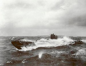
 UB-148 at sea, a U-boat similar to UB-122.
| |
| History | |
|---|---|
| Name | UB-122 |
| Ordered | 6 / 8 February 1917[1] |
| Builder | AG Weser, Bremen |
| Cost | 3,654,000 German Papiermark |
| Yard number | 295 |
| Laid down | 21 May 1917[2] |
| Launched | 2 February 1918[3] |
| Commissioned | 4 March 1918[3] |
| Fate | Surrendered 24 November 1918; scuttled English channel 1 July 1921 |
| General characteristics [3] | |
| Class and type | Type UB III submarine |
| Displacement | |
| Length | 55.85 m (183 ft 3 in) (o/a) |
| Beam | 5.80 m (19 ft) |
| Draught | 3.72 m (12 ft 2 in) |
| Propulsion |
|
| Speed |
|
| Range |
|
| Test depth | 50 m (160 ft) |
| Complement | 3 officers, 31 men[3] |
| Armament |
|
| Service record | |
| Part of: |
|
| Commanders: |
|
| Operations: | 2 patrols |
| Victories: | None |
SM UB-122 was a German Type UB III submarine or U-boat in the German Imperial Navy (German: Kaiserliche Marine) during World War I. She was commissioned into the German Imperial Navy on 4 March 1918 as SM UB-122.[Note 1]
UB-122 was surrendered to the Allies at Harwich on 20 November 1918 in accordance with the requirements of the Armistice with Germany. Having been exhibited at Southampton in December 1918, she was then laid up at Portsmouth until scuttled in the English Channel on 1 July 1921.[5]
Although contemporary Admiralty documents leave no room for doubt as to UB-122's fate, her name has become widely associated[6] with one of three submarine-wrecks in the Medway,[7][8] which another Admiralty document makes clear can only be one of UB-144, UB-145 or UB-150.[9]
Construction
[edit]She was built by AG Weser of Bremen and following just under a year of construction, launched at Bremen on 4 March 1918. UB-122 was commissioned later the same year under the command of Oblt.z.S. Alexander Magnus. Like all Type UB III submarines, UB-122 carried 10 torpedoes and was armed with a 8.8 cm (3.46 in) deck gun. UB-122 would carry a crew of up to 3 officer and 31 men and had a cruising range of 7,280 nautical miles (13,480 km; 8,380 mi). UB-122 had a displacement of 512 t (504 long tons) while surfaced and 643 t (633 long tons) when submerged. Her engines enabled her to travel at 13.9 knots (25.7 km/h; 16.0 mph) when surfaced and 7.6 knots (14.1 km/h; 8.7 mph) when submerged.
References
[edit]Notes
[edit]- ^ "SM" stands for "Seiner Majestät" (English: His Majesty's) and combined with the U for Unterseeboot would be translated as His Majesty's Submarine.
Citations
[edit]- ^ Rössler 1979, p. 55.
- ^ Helgason, Guðmundur. "WWI U-boats: UB 122". German and Austrian U-boats of World War I - Kaiserliche Marine - Uboat.net. Retrieved 13 February 2009.
- ^ a b c d Gröner 1991, pp. 25–30.
- ^ Helgason, Guðmundur. "WWI U-boat commanders: Alexander Magnus". German and Austrian U-boats of World War I - Kaiserliche Marine - Uboat.net. Retrieved 10 March 2015.
- ^ Dodson, Aidan; Cant, Serena (2020). Spoils of War: the fate of enemy fleets after the two World Wars. Barnsley: Seaforth. pp. 54, 130. ISBN 978-1-5267-4198-1.
- ^ Ultimately connected with the wholly erroneous statement in Gröner 1991, page 29, that she "ran aground off the East Coast of Britain on the way to being broken up, 1921" - a fate that he wrongly attributes to a large number of other boats.
- ^ Wreck location shown on Google Maps https://maps.google.co.uk/maps?q=51.430667,0.631983&hl=en&ll=51.430636,0.632014&spn=0.000741,0.002382&sll=52.8382,-2.327815&sspn=5.88034,19.511719&t=h&z=19
- ^ "Historic wreckage of German First World War U-boat revealed in low tide". The Telegraph. London. 20 December 2013. Archived from the original on 20 January 2018. Retrieved 5 October 2020.
- ^ See Dodson and Cant, pages 100-101.
Bibliography
[edit]- Bendert, Harald (2000). Die UB-Boote der Kaiserlichen Marine, 1914-1918. Einsätze, Erfolge, Schicksal (in German). Hamburg: Verlag E.S. Mittler & Sohn GmbH. ISBN 3-8132-0713-7.
- Gröner, Erich; Jung, Dieter; Maass, Martin (1991). German Warships 1815–1945, U-boats and Mine Warfare Vessels. Vol. 2. Translated by Thomas, Keith; Magowan, Rachel. London: Conway Maritime Press. ISBN 0-85177-593-4.
- Rössler, Eberhard (1979). Die deutschen U-Boote und ihre Werften: eine Bilddokumentation über den deutschen U-Bootbau; in zwei Bänden (in German). Vol. I. Munich: Bernard & Graefe. ISBN 3-7637-5213-7.
